Off we go coughing and sneezing
but much refreshed, we head for, yes, you guessed it, The Grand Canyon. No
point starting small, it’s the closest, so why not start at the big one. The
info from Sedona was a great help to understanding how the Grand Canyon formed
and WOW what a magnificent sight to behold from our first sight at the
Watchtower in the east, all along the South Rim walking trails and down a
1.5mile trail (about 0.1mile or 500ft vertical) into the canyon itself.
Unbelievable and no photo can do it justice. It must be seen and experienced.
We wanted to go further down into the canyon which descends 1 mile or 5,000ft
vertically from the southern rim to the Colorado River but the escalator back
to the top was out of order and to ride a mule you have to book 1 year in
advance.
 |
| The Watch Tower at the Eastern end of the Grand Canyon South Rim |
 |
| The canyon looking north |
 |
| The canyon looking northwest from South Rim @ 7,000ft elevation, North Rim in the distance is 8,000ft, the trail in the foreground leads to Plateau Point @ 3,800ft the Colorado River is another 2,000ft below the point in the adjacent canyon. WOW!! |
 |
| Aussie canyoning attire, thongs (flip flops here in the US) and boardies. Not good for repelling rattlers but I can crack walnuts between my heels now. |
 |
| A view from inside the canyon about 500ft below the rim |
 |
| A ground squirrel, they bite, scratch and have rabies but boy aren't they cute lookin |
 |
| The mules have right of way on the trail down the canyon and rightly so as they bite and kick when patted. |
 |
| Even the locals need directions coz this canyon is just so BIG!! |
After 3 days walking and climbing
with aching legs and quenched thirst we head northeast and take a scenic
highway through part of the Navajo Reservation which looks to us as
inhospitable desert country but they seem to enjoy the place. It’s part of a
huge area given back to them, the largest of many Indian reservations in the
USA. The Navajo make and sell beautiful silver jewellery, rugs and pottery,
unfortunately out of our price range, despite some hard bartering, much tougher
than Asia! From here we cross the famous Colorado River via the, yes you
guessed it, The Navajo Bridge.
 |
| The mighty Colorado River averages 150m across and 30m deep |
 |
| Canyon cliffs were once homes to ancient people living in caves |
 |
| Amazing views along the highways |
 |
| Wide open spaces where the Buffalo roam, well used too |
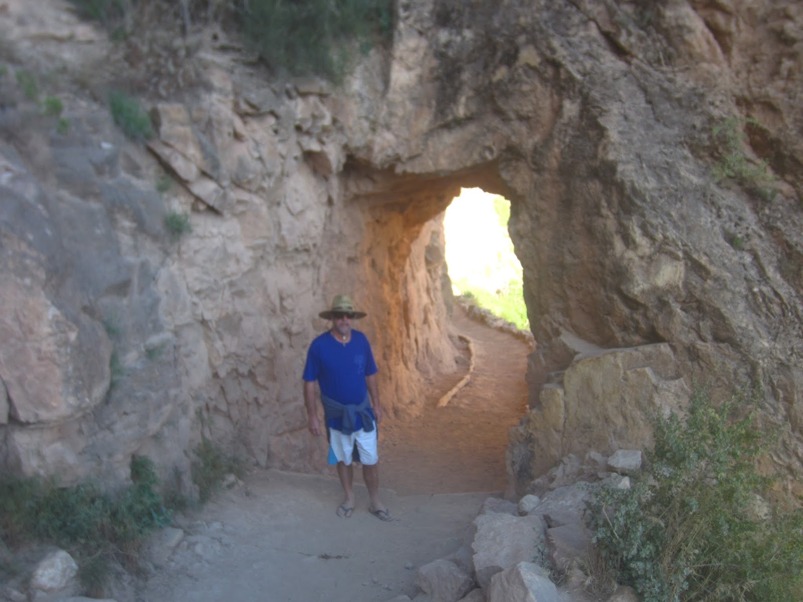
Our next stop is Zion Canyon across
the border in Southern Utah, again WOW, this time we drive along the bottom of
the canyon after traversing a 1 mile long tunnel carved through a mountain
giving us a totally different perspective of Canyons. The tunnel was built for
horses with wagons not RV’s so for a $15 fee the traffic is stopped at the
other end and we have to drive down the middle of the road hoping our 12ft
clearance is not compromised part way through. This canyon system is easily
accessible by foot, push bikes and shuttle buses making it very crowded with
Americans on vacation. We did 1 trail through a canyon carved by the adjacent
Virgin River and it was incredible. That night we found a free camp on the rim
of another smaller canyon carved by the same river.
 |
| Entering the tunnel at Zion NP our RV is 12ft high and 10.5ft wide, it's like driving a tank through the eye of a needle |
 |
| Magnificent canyon views |
 |
| Living on the edge, our camp for the night |
 |
| Breath taking scenery through this canyon |
Next day we headed for another
canyon also part of Zion Nation Park at the NW corner, it also was spectacular
and after talking with some local tourists we learned about the trees and
plants which we have been observing at these altitudes, various different
pines, summer flowers and cacti. All these places above 5,000ft get snow in
winter so the vegetation is very hardy despite its fragile appearance.
Mountains above 12,000ft have snow all year round which surprised us until we
saw it ourselves when we drove over a mountain in Dixie National Forest at
9,300ft later that same day, where we camped again in another pine forest, but
this time rugged up in woollies. Mt Kosciuszko at it's peak is only 7,300ft. It was at this campsite we heard our first gun
fire. We can only assume it was someone out hunting which seems to be legal
everywhere in the US. It doesn’t stop with animals 34,000 people die every year
from guns in the US.
 |
| The white in the photo is remnant snow/ice as we pass through Dixie National Forest |
 |
| Kolob Canyon northern part of Zion NP |
 |
| Camping at 9,300ft as cold as ice!! Aspen trees in the background |
On again to yet another canyon this
one arguably the prettiest was Bryce Canyon with it’s uniquely eroded
formations which are spectacular. Viewed from both the rim and from down at the
base via the 2 mile long, again you guessed it, Navajo Loop Trail which weaved
us through a very steep slot canyon and amongst heaps of Hoo Doos (tall rounded
isolated formations). The variety of colours within the sandstone formations
can bedazzle one for ages and understanding the mechanism by which they are
formed is fascinating while the time frame involved is totally mind boggling.
In comparison OZ is so old geographically and a seismic non-event it has
virtually been washed away except for 1 big rock in the middle and some hills
along the east coast.
 |
| WOW, Bryce Canyon arguably the most scenic canyon |
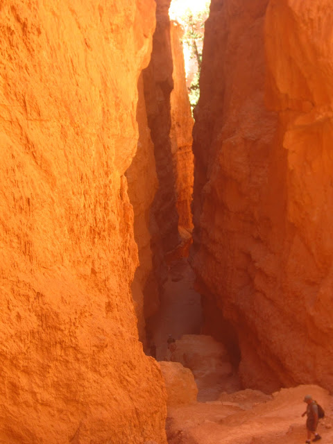 |
| A slot canyon |
 |
| Looking up from part way down |
 |
| WOW again!! |
 |
| A raven, similar to our crows but bigger and meaner looking |
 |
| An arch formed by ice thaws, wind and rain |
 |
| Hoo Doo's at the top, performing a balancing act |
 |
| More hoo doo's with the valley in the back ground |
The next day was a long drive NE
via Capital Reef National Park, smoko was at a quaint cottage at Wild Cat
Visitor Centre where we were given free coffee and scones freshly baked on an
old arga stove top, fired by an unlimited supply of aspen wood, lovely couple
of ex yachties who volunteer each year to help, for free RV accommodation.
 |
| Our highest elevation so far |
Refreshed and feeling fit and
being experienced canyoners now, we decided to tackle 2 national parks in the
same day, Canyonlands and The Arches in Eastern Utah, again WOW is the
superlative, still part of the Colorado Plateau these 2 adjacent parks have
unique formations resulting from similar mechanics where salt lakes were formed
from the ingress of the sea and huge deposits of salt covered with sediment
caused massive uplift and after millenniums of erosion created magnificent
canyon walls. These walls have since been eroded by ice, wind and rain to form
grand arches spanning huge distances. We walked ourselves almost into oblivion
and managed to get to the next town called Moab just on dark, parked in the
street and decided to have our first bought dinner at a posh steakhouse. The
service and food was excellent but not cheap, we left a tip and crashed for the
night in the RV outside.
 |
| The mountains in the distance still have snow in Summer |
 |
| Canyonlands NP, Utah |
 |
| Rockin On |
 |
| Arches NP Utah |
 |
| "Delicate Arch" |
 |
| North and South Arches |
 |
| Looking at the rock formations can you see the man on the left talking to the woman lower centre at the "Garden of Eden" |
 |
| "The Balancing Rock" |
 |
| "Tower of Babel" |
 |
| "Courthouse Towers" |
Still gluttons for punishment we
headed south to another national park called the Natural Bridge National
Monument, these formations are again unique in that they are formed when a
meandering river deep in a canyon decides to take a short cut straight through
the adjacent wall, the erosion creates a bridge like structure similar to a
tunnel. We hiked down into the canyon at 2 of the 3 bridges despite the
temperatures exceeding 40C and guzzled so much water we lost count of the
bottles. We camped up for the night at an old landing strip in the middle of
nowhere, ate and crashed.
 |
| Natural Bridges NP |
 |
| The softer red layer is eroded away faster than the above layer creating the bridge structures |
All the while we’ve been
travelling outside of built up areas we’ve had very poor internet and phone
service despite being told AT&T was the best provider, we were hoping to
head to the Glen Canyon which is part of the Colorado River east of the Grand
Canyon, a huge lake held back by a dam wall. A water playground in the desert.
To avoid a huge backtrack we needed to be assured that a vehicle ferry that
traverses Lake Powell (named after the first man to travel through the entire
Grand Canyon by boat) would accommodate our RV, unfortunately we couldn’t make
the call. Instead we decided to head to another free camp called Goosenecks
where a river meanders so much it creates a canyon which looks like a goose’s
neck. Sam advised us to take a much longer route, we argued with her, then
ignored her advice. 30 mile later, we turned back on the road we had taken and
ironically had to then take Sam’s now 130 mile plus backtrack, to get around
the obstacle which we found was a rutted dirt road through a steep canyon with
major switchbacks and a speed limit of 5 mph with fears of road collapse, we
had been within 5 mile of our destination. This explained why we didn’t see any
vehicles coming in the opposite direction. Our maps showed a byway similar to
all the others but the risk to us and the RV was too great. We apologised to
Sam for doubting her obviously superior knowledge of the area and vowed never
to argue again.
 |
| Hwy 163 through Monument Valley |
Pressing on south now, we passed 5
mile away on the other side of the intended gooseneck stop, and re-entered the Navajo
Reservation via Monument Valley, a spectacular highway through huge mesa
formations and camped in a free park at the yes you guessed it again the Navajo
National Monument, a canyon with remains of ancient dwellings formed from mud
and stones under huge ledge formations. It’s conjecture whether or not the
Navajo ancestors ever lived in these dwellings which we were informed are
ancient Puebloan dwellings. The Navajo are renowned for their story telling and
copycat traditions.
 |
| A closer view of the Mesa's or what's left of them |
Just to let you know, we’re
heading south again because we have to return to Cruise America in Mesa to pick
up our RV Title along with our bank debit cards and roadside service cards. The
title takes 2 weeks to process and we are currently travelling on a 90 Day
temporary Arizona registration. The vehicle is titled in California and we need
the title so we can send it to Montana where we will arrange for our LLC
Registered Agent to register the RV for us, rather than us travelling all the
way to Montana. If this sounds confusing it is, anyway on with the blog.
 |
| Bigger is better for this guy |
The Navajo Indian Reservation is
huge and takes all day to cross, we stopped at several places en-route hoping
to find a bargain but to no avail. In the middle is another reservation for
Hopi Indians, these Indians are different to the Navajo, lighter skin colour
and very different traditions. They have a closer connection to the ancient
Puebloans, maybe even the Aztecs and are famous for making Kachinas (weird
dolls carved out of cottonwood tree roots, painted in very bright colours, dressed
in costumes and decorated with feathers). Each kachina, as it was explained to
us by a carver, has a story of purpose and represents an aspect of the Hopi
spiritual beliefs. The costumes are the same as they wear during ceremonies
such as a rain dance or stop no more rain dance. We tried to buy a kachina, but
the guy wouldn’t budge on price. The prices they charge would make Indian
Barbie a bargain.
 |
| The famous Route 66 looks more like the road to nowhere |
Next stop saw us “Standing on the
Corner” at Winslow, Arizona on Route 66. How more American can you get, and
probably more photographed than the Grand Canyon. Route 66 which used to
connect Chicago to LA and all stops in between is now a byway in parts being
overgrown by interstate highways. All the towns still highlight the nostalgia
and of course Winslow is the most famous after the Eagles song. Other than
that, Winslow is pretty quiet, has a great free park at McHood Lake State Park
where we stayed a couple of days trying to sort out our internet or lack of it.
 |
| "Standin on the Corner" |
We then headed to the Petrified
Forest National Park, 50 mile to the east along I 40 highway (now I’m sounding
like Sam), WOW again, petrified ancient pine trees with pieces the size of cars
to splinters resembling wood chip just lying scattered over the desert. An
amazing sight close up to some pieces which show the colour variations and even
the growth rings of the trees, most still had the bark on them as if turned to
stone in an instant. Huge fines are imposed if anyone is caught stealing
pieces, they even ask you to be a dobber if you witness anyone. The day was
stinking hot, again above 40C as we were at 4,000ft elevation, the lower the
elevation the hotter it is. After the park we headed to another pine forest at
about 6,000ft to a camp site close to the Mogollon Rim, this is the edge of another canyon
where snow skiing in Winter and escaping the heat in Summer is very popular,
it’s also the last retreat before heading back down to the hot deserts of
Southern Arizona which are about 1,000ft elevation.
 |
| Massive petrified logs scattered all over what we would call desert but was once tropical rainforest |
 |
| You can still see the bark and growth rings |
Back in Mesa we collect all the
items waiting for us and then present CA with a list of items identified in our
first 2 weeks which we feel should have been attended to as part of the
“Refurbishment Process” nothing major but things we would have to fix. They
agree whole heartedly and we book in for 0930 the next day, the temp was
expected to climb to 45C in the afternoon dropping to 40C in the evening and 35C
by morning, so after activating our debit cards at the bank, we parked up
across the road, outside a mortuary and ran the generator half the night with
the AC full bore, still we melted just like the ice cream in the freezer. We’ve
been to some pretty hot places around the world but Mesa in summer is the
hottest yet. Outside the air burns your skin and sucks the moisture right out
of your mouth, no amount of water satisfies. 5 trail walkers died in Arizona
that day, which just happened to be the northern Summer Solstice June 22.
 |
| This piece of petrified wood took 3 weeks to cut and polish the face and is worth about US$10,000 |
By morning it’s bearable so after
some shopping we head over to CA and they get stuck in, everything plus more is
attended too and after farewells and vowing never to return to Phoenix in
summer we head for the Naval Observatory pine forest at Flagstaff, our favourite campsite so far.
Here we will stay for a while to finalise our Montana registration and get our
plates sent to us hopefully within a week. So far in 3 weeks we've travelled over 2,400 miles and been to some amazing places, next week the adventure continues, 12 more weeks Yeha!!
 |
| Our little friend 'Cotton Socks" ain't he cute |
Seeee Yaaawl!!!
 |
Beers and Cheers with a nice drop of 'Sailor Jerry's' spiced Caribbean rum named after a famous Hawaiian tattooist
PS: Think it's time for a new camera!!!
|
J&J