Blog No 6
We cruised across the Washington State border at Dulles, another bridge across the Columbia River, this one without a toll. Toll avoiding is our specialty, providing the drive is worth it. This time it was, the drive down into the Columbia Gorge was spectacular. Heaps of tunnels although quite narrow and without much clearance we wound our way along westward.
 |
| Our RV is 12 feet high and nearly 10 feet wide so it makes for an interesting approach to this tunnel luckily nothing comes the other way |
We stopped at the Bonneville Dam where we had a partially guided tour through the workings of the dam structure and hydropower plan. The free tour included a talk by one of the local rangers about how the salmon and other species migrate upstream, climbing the fish ladders and although totally exhausted manage to get back to their spawning ground.
 |
| A Lamprey is a fish version of a leach but about 3 feet long, here it attaches to the glass viewing wall for a rest while traversing the ladder |
The dam also includes a lock enabling large vessels to pass upstream, this is one of many similar dam and power structures on the Columbia - Snake Inland Waterway providing both electrical power and fresh water supply to the many people who live in the region. The catchment basin is huge covering the whole eastern side of the state.
 |
| Several Chinook Salmon traversing the ladder |
We made our way north to Mount St Helens National Monument. This mountain is the continent’s most recent major volcanic event (1980). It wasn’t an eruption in the traditional sense but more like a huge avalanche, as half the mountain collapsed sliding into the adjacent Spirit Lake. A plume of superheated gas, water and pumice blew skywards and within seconds had scorched everything for miles around. The avalanche pushed the lake water 250ft up the adjacent mountain side dragging back with it all the dead trees and topsoil. The lake rose significantly after the rubble partially filled it. Many people who owned properties on the lakes edge who had refused to leave were killed instantly, and what properties weren’t covered in rock were covered in water.
 |
| Remnant devastated pine trees on a hill on the way up to Mt St Helens |
 |
| Very healthy new growth White Pines |
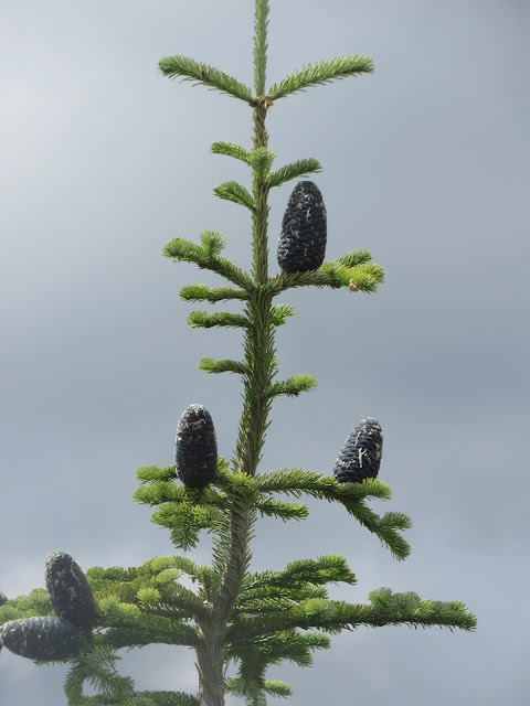 |
| White Pines with mature cones |
 |
| And again with different cones, could be a different variety |
We decided to stay at the main lookout for the night against all park regulations hoping to get a clearer photo the next morning. At 7,000 feet elevation it was pretty cold even in the RV. Access beyond the carpark is restricted to day use only. The next morning we saw our first coyote. It was smaller than we thought it would be and very mangy looking, but too quick for us to get a shot. It must have sensed our presence while we fussed about in the RV.
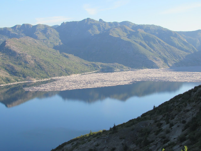
 |
| Spirit Lake with its mass of fallen trees which have remained floating here since 1980 |
 |
| Ditto zoomed in |
 |
| Mount St Helens facts |
 |
| Mount St Helens in the early morning, it's easy to see the portion that fell away |
 |
| Ditto with its newly formed cinder cone |
 |
| Spirit Lake, the avalanche pushed water 250 feet up the sides before retreating and dragging down all the trees |
 |
| Ditto |
 |
| This early morning shot shows the enormity of the place with RV all alone in the car park below |
 |
| Bike riding around these mountains is very popular but also due to the bear population could be considered foolish. It's common for these people to be referred to as "Meals on Wheels" |
 |
| This could prove to be a safer option although very strenuous up mountains |
Our next destination was the infamous Mount Rainier National Park (pronounced Renear) it’s the highest mountain in Washington State at 14,411 feet. It is a classic looking volcanic peak and declared to be the next most likely cataclysmic volcanic event on the continent. The mountain has 25 glaciers most of which are active and the volume of melt water which flows down into the river system is mindboggling.
 |
| One of the many glacial lakes at Mt Rainier |
 |
| A grassy meadow, perfect ski slope in winter |
 |
| Active edge of glacier |
Active glaciers are an ever changing ice mass which is moving and continually grinding and crushing the rock below. The ice mass buckles and fractures, can be hundreds of feet thick with deep chasms. Below the ice, rock flour (finely ground rock particles) flows into the water creating the dirty looking water, and also the various coloured lakes which seem to pop up everywhere. If a rivers water is clear it generally means that its origins are from a passive glacier or general snow melt. Surprisingly in all the rivers we have been to, the water is a lot warmer than we’d expect.
 |
| A lake turned green from the rock flour that comes out of the glacier |
Our first day was spent high up on the northern side of the mountain hoping to get a clear view. The mountain is so big it creates its own weather and is mostly obscured by cloud so photos are generally not so good, also because it’s so big it’s hard to photograph without a wide angle lens.
 |
| Mount Rainier looking from the South East |
 |
| Ditto in the late afternoon |
From the northern face we headed back south and then west through the lower section of the National Park. In a small corner of the park we found an old growth forest with some huge specimens of Western Red Cedar and Douglas Fir (Oregon Pine) up to 1,000 years old.
 |
| A suspension bridge on our way to the old growth forest |
 |
| A chipmunk looking for a feed |
 |
| Exposed root system from a fallen tree |
 |
| Giant Western Red Cedar trees |
 |
| Giant Douglas Fir trees |
We pushed on to a small town called Eatonville where we collected our RV title which we had arranged with our agent to post first class mail from Montana 500 mile away. It had now taken a total of 7 weeks including the 10 day postal service to finally have our very own proof of ownership.
 |
| Nerada Falls in the Mt Rainier National Park |
It’s a user pays system here no doubt about it, the haves and the have nots, with a large gap between, we have been amazed how many people we have seen on corners with cardboard signs begging for food, work and anything they can get. We’ve had people approach us begging for money just to put gas in their cars. Modern day beggars with everyday needs.
 |
| Terminal Moraine, unconsolidated debris at the end of a glacial flow |
Anyway it’s back to the Cascades as we head east through the mountains again. We camped up in a small ski park on the side of the scenic highway. The next morning we virtually climbed up a trail to an alpine lake high up in the mountains, it was only a couple of mile but the change in elevation surprised us and certainly stretched our calf muscles, no mention of this on the signpost. The water was freezing as expected and the lake was full of rainbow trout. We could see them from the shore jumping and swimming about.
 |
| Alpine lake in the Northern Cascades well worth the hard slog to get there |
 |
| A rainbow trout lurking at the waters edge you can just see the pink along its belly |
In winter this area is a magnet for snow skiing enthusiasts and the closest town is Leavenworth (not the Federal Penetentiary). This town is famous for adopting a Swiss Alps theme and everything that goes with it. Smallgoods and beer were certainly our attraction. We have been missing our quality salami and cheese products so readily available back home but alas a taste not yet developed here in the US. Surprising for a country considered to be a melting pot of nationalities. Its only when a town like Leavenworth makes a special effort that the norm is broken.
 |
| Says it ALL |
 |
| Swiss Alps style facades make this town home to many European immigrants |
The amount of business this town attracted in the single day we stayed was astounding and it’s no wonder Walmart and Safeway don’t have stores here, their products couldn’t compete taste wise. They could learn a bit about variety being the spice of life and the benefits of a multicultural society. We stocked up with a variety of salami's and cheeses which will hopefully last for many weeks to come.
 |
| Not a problem in summer but how does one do this in winter without bumping into something |
After a good session in the Icicle Brewery we headed north along the Columbia River (again but much further up) and then a left turn along the Methow River to a camp site in a rest area within hear shot of the river. The river drowned out the highway noise and the few beers helped us sleep right through till morning.
 |
| The Northern Cascade Mountains are quite ragged |
The highway back west through the Northern Cascades was spectacular and well worth the many miles. It’s these mountains where the Canadian Ice Flow terminated 10,000 years ago in the last ice age. The mountains have their own remnant glaciers many of which melt each year now adding to the great volumes of water cascading into the river system. It’s only the very high peaks which remain ice covered all year round.
 |
| Liberty Bell rock formation is at the top of the range and perhaps a great relief to the many pilgrims in the 1800's |
 |
| A glacial lake in the Cascades, these lakes are large and deep |
Mount Baker is the highest of many similar peaks in this region which like their southern counterparts are still volcanically active. It’s here where we see many large lakes which were created by the retreating permanent glaciers of the ancient Canadian Ice Flow. The lakes are now fed by the yearly melts and the much smaller active glaciers.
 |
| Mount Baker in the distance |
After nearly 2 months of mountains and canyons it time to head for the sea and the taste of saltwater again. We head west to Whidbey Island which is in Puget Sound north of Seattle. It’s accessed via a stunning bridge from the mainland peninsula.
 |
| Not even the view is free on this island, we did however steal a quick peak |
 |
| View showing parts of Puget Sound from the bridge accessing Whidbey Island |
The island is about 50 miles long so an easy day trip with a night stop midway along the return. We got a taste of the US seaside with a couple of beach stops along the west coast. The beaches are nowhere like ours but at least it’s a good change of scenery. Access to the waterfront in general is very restrictive ensuring secluded privacy for those with properties, many of which own the section of beach in front. Many of the waterfront properties are also at risk of falling into the sea as the cliffs surrender themselves up to the westerly gales which frequent this place in the winter months.
 |
| Houses perched on the side of a very soft cliff just waiting to fall |
 |
| Kelp beds just of the beach, would make it difficult for swimming if the water was warmer |
 |
| Kelp washed up on shore looks more like a sea monster |
At the North Eastern end of the Peninsular section, the mainland is a protected bay with a modern marina precinct similar to OZ with mainly small yachts and fishing boats, nothing outrageous which surprised us and a virtually non-existent commercial fishing fleet. Many boats appear to live on the hard with several large haul out facilities. The commercial precinct appears to be primarily setup for major shipping and possible interaction with Alaskan mining, oil and gas projects.
 |
| 970 year old Douglas Fir cut down during the timber boom |
Heading north again we stock up with food, fuel and Canadian cash and approach the border for a crossing. Unlike the boat we will be restricted severely on the amount of alcohol we can take across as it’s much more expensive than the states.
 |
| The Lady of the Sea |
 |
| Good to see someone watching out for us |
Bye For Now
Beers and Cheers drinking Crosscut Pilsener at the Icicle Brewery in Leavenworth, the best US brew so far
J&J


