Blog no 7
Up early we hit the border at
Sumas hoping to miss the crowds as we discover that although it’s only Friday
it’s also the beginning of a long weekend in Canada, it seems we always manage
to enter countries on holiday weekends. Happened to us all the time in Asia
too. It’s also the beginning of school holidays in Canada so time will tell.
We’ve managed to have summer school holidays everywhere we’ve been so far.
 |
| We are hoping to see a few but not up close |
Our first day was spent getting
info from the visitors centre in Abbottsford and sorting out phone/internet at
Walmart. We decided to roam on our US sim card rather than purchase a Canadian
card with a different number. Surprisingly, it was about the same cost for the
month. The service coverage was the same, only problem was we lost our option
for cheap calls to OZ, despite being told we wouldn’t. Oh well, that’s phone
companies for you.
 |
| Hoping to see a few of these moose but again not close up, they are responsible for more human deaths than bears |
We planned our route for the next
month with the intent of doing a big loop of about 3,000 miles (5,000km) which
would take us northeast along the “Gold Rush Trail”, then northwest, and finally
south back to the US border. A huge area encompassing mountains, plains,
rivers, lakes and the Pacific Ocean. It’s now the last month of summer and we
expect temperatures between 10C and 30C, sunny days with little rain.
 |
| A grizzly bear close up, lucky for us it's stuffed |
We headed east on Saturday
morning after a night in the Walmart carpark, picked up some beer at the liquor
store where we had to pay a deposit on the cans, 10 cents each, refundable when
you return them. It’s also a popular source of income for the “not so well off”
here in Canada, beats holding up begging signs all day, they just lug a big
sack around dumpster diving instead.
 |
| Canada Geese taking advantage of the lush grass |
 |
| A Bald Eagle in flight |
Canada is more RV friendly than
the US in that they provide free dump sites for grey and black water along with
fresh potable water to fill our tank. The locations are all shown on an APP we
have called Wikicamps. Facilities are available in most towns, making it much
easier to keep mobile. The food here in Canadian grocery stores is very similar
to OZ a big improvement on the US.
 |
| One of the many colourful examples of RV's travelling around |
Out on the highway we strike a
traffic jam with holiday makers heading east so we stop at another Walmart this
one in Chilliwack where another 2 Majestic RV’s park up on both sides, one
Canadian and the other Kiwi. Both the same size but older models.
 |
| Looks like a Majestic sales yard at this Walmart carpark |
We decide to spend 2 nights in
Chilliwack catching up on things and letting the holiday makers settle before
heading off to the Bridal Veil Falls deep in the forest.
 |
| Bridal Veil Falls |
As we head up the highway
adjacent to the Fraser River Valley, the scenery changes from lush forest to a
drier environment almost desert like, with ragged mountains and saltbush. It’s
quite stunning, but a surprise to see such dry conditions. The river has a
tremendous flow from a huge catchment stretching from the coast up to the Rocky
Mountains further east.
 |
| This part of the Frazer River Valley is in a rain shadow creating desert like conditions |
Our first camp is on the side of
a chasm formed from a glacial river which existed until the end of the last Ice
Age about 10,000 years ago. The river is now just a creek which trickles down
about 500 feet into the valley below. Testament to the power of ice and water.
 |
| The Chasm |
 |
| Ditto |
The next night was a rest area on
the side of the highway where Jen met a couple of First Nation (Indigenous)
women who advised her that the wild life in this part of Canada is no longer
what the advertisements proclaim and most is limited to the very few National
Parks and along the Rocky Mountains. This info confirmed what we had suspected
in the 2 days so far. Plenty of signs warning of crossing wildlife but not a
single roadkill sighted in 500 mile. In the US we didn’t see a lot of wildlife
but we did see some roadkill especially squirrels. It’s definitely an accurate
telltale.
 |
| A pair of Sandhill Cranes |
Refusing to be dissuaded we
decide to go bush, we’re far enough away from major towns and cities we would
expect to come across a few critters surely. We found a nice lake in the middle
of nowhere with a couple of campsites which by dark were all full. We were
informed that the wolf like howl we heard during the afternoon was in fact a
bird called a Loon. It’s a water bird which mates for life and the sound it
puts out day and night sounds anything but bird like. It’s also the figure on
the $1 coin and as such the coin is commonly called a “Loonie”.
 |
| A Loon swimming on a lake |
We head off early with a 50 km
drive along a logging road back to the highway, the road’s very rough as we
expected and not sign posted at all, it’s navigating by compass (Michelle can’t
distinguish the difference between a logging road and a hiking trail), anyway
luckily only a few trucks pushed us to the side. The roads are provided by the
logging companies and as such are not well maintained, the ones which service
private properties are better but not great, and as such take their toll on the
vehicle, driver and passenger. We see a few animals but not the ones we were
expecting or hoping for.
 |
| One of the very many logging trucks that thunder past, they own the roads here, literally |
Along the way we discover where
the term “make hay while the sun shines” originated. Every square millimetre of
land which is not being logged is set aside for growing hay. We were informed
that 1 cow eats 2 bales per winter, why we couldn’t see many cows seemed to us
quite bizarre as the amount of hay would easily have supplied the entire cattle
population of OZ. Where it all goes was one question no one could answer, they
said it just goes.
 |
| More bales of hay than you can count in one paddock, this picture is typical for much of British Columbia |
 |
| One of the very fortunate free range cows that will never starve here in Canada |
 |
| Rather than free range these cattle are in pens and fed hay |
Prince George is the main city in
the northeast and also where we start to head northwest. It’s a railhead on the
Fraser River and a supply centre for many more remote logging and mining towns.
For us it’s a fuel, fruit and vegi supply stop.
 |
| With piles of logs like this in every town its hard to believe there are any forests left |
Heading west we start getting
away from the semi’s and it becomes a much more peaceful journey. This area is
full of lakes many of which are iced over in winter. The lakes are reportedly
full of fish, mainly trout and some salmon but you need a boat to get to them.
Nearly all the lakes are accessed via logging roads, which is disappointing, as
the poor quality is very restricting for us. Some are loops which is good while
others just fade out into the distance at a desolate place in the woods.
 |
| Aussie RV splattered after a trip along the logging roads |
We were hoping to see some
wildlife at these lakes and along the back roads but unfortunately it seems
they were all here last week or last month or even come back next month or
winter time, everything but now?????? The locals don’t really want the wildlife
nearby where they live and travel.
 |
| Even these cute little fellows are disliked by locals because apparently they bite, scratch, have rabies and also their fleas carry the black plague. WOW this can't be true surely. |
One evening at Burns Lake we were
woken about midnight by the sound of sirens blaring which then went
intermittently for about 3 hours. The next morning while driving down to
another lake, we were stopped at a road accident which we assumed was the cause
of the sirens. The single vehicle was in a ditch and totally mangled,
definitely no survivors. This was confirmed on the local news and the cause was
assumed to be a moose. We doubt it, more likely just speed to cause the amount
of damage we saw.
 |
| This deer was seen just down the road from the accident and since they frequent the town outskirts to protect their young from predators we wonder if she could be the culprit, It looks like a fresh wound on her side |
We travelled more back roads in
search of wildlife but to no avail, too many thunderous logging trucks and dust
to have anything close by, we think we need to go much further away from
civilisation. Despite all the warning signs and every garbage bin being a bear
resistant bin there was not a single indication of their presence. We expected
to see moose, elk and antelope in most places but again we were told they only come
down to the road and close to towns in winter, they head for the hills in
summer or further north. The complete opposite to what we expected.
 |
| Catching salmon and recording what fish are in the river |
We decided to head for the west
coast where we knew that summer was the time for salmon to return to their
spawning grounds, surely bears would be catching the salmon while they swim
against the river flow.
 |
| Only 1% make it up through the water fall, most have to climb the fish ladders |
After a couple of camps and 200km
north up the Alaska Hwy we turned left and headed through a very scenic valley
to a seaport town called Stewart and the southern Alaska border town Hyder.
 |
| Hyder the sign says it all |
 |
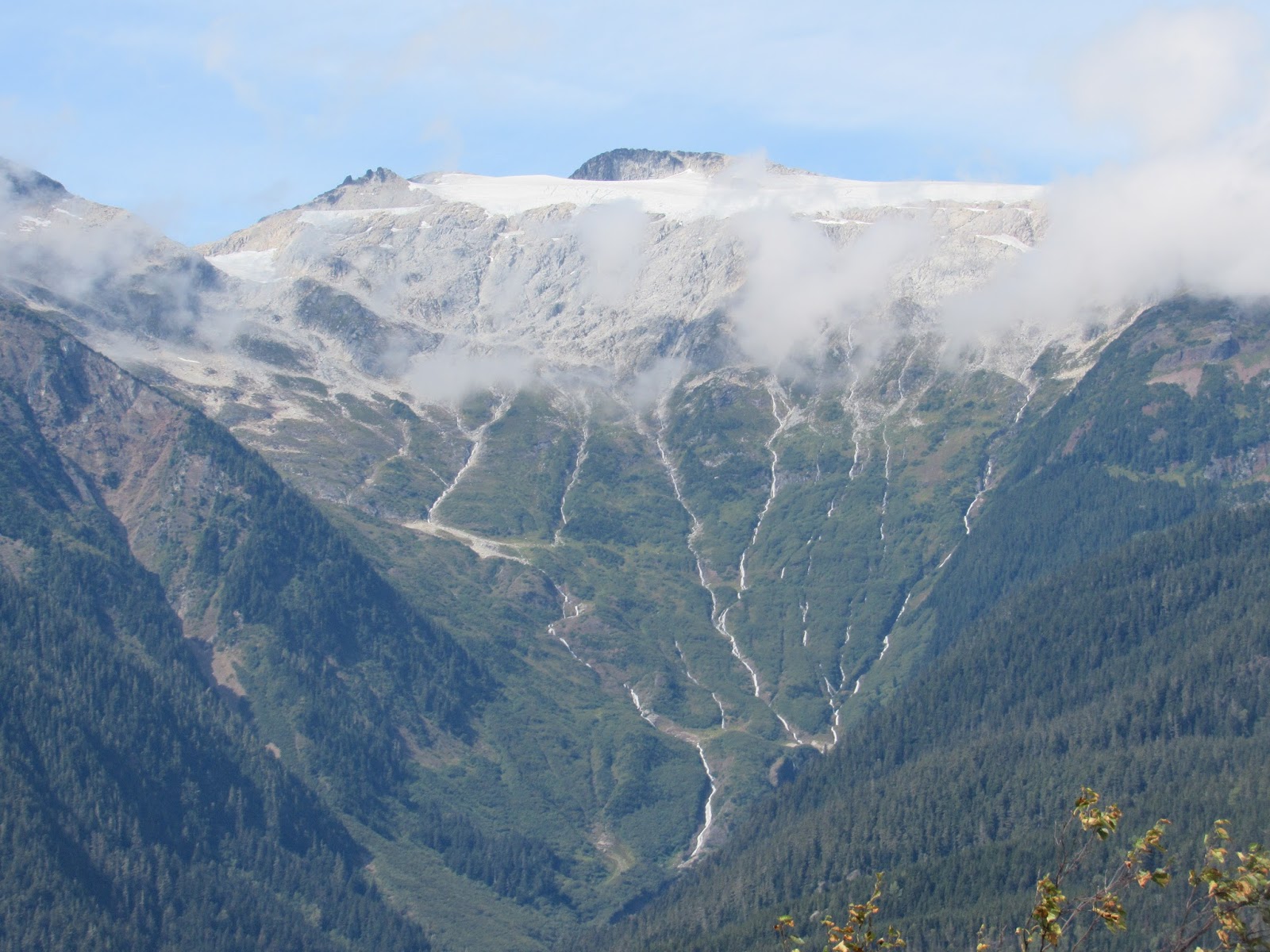
| Bear Glacier enroute to Stewart |
 |
| A male Pink Salmon with the distinct hump it develops when returning to spawn |
Hyder has 1 main road which leads
out of town north for about 50km to the Salmon Glacier which is actually back
across the border into Canada. The road is unsealed, with ruts and potholes, climbs
about 4,000 feet to the summit and while we drove, it was shrouded in mist and
fog. A very dangerous drive, but well worth the effort. We hung at the summit
for a couple of hours with little sign of it clearing, another couple from
Germany had been waiting there 2 days for a clear view. The location would be
fog bound more than 50% of the time even in summer making it extremely
difficult for any road maintenance. The road used to go down past the summit to
give access onto the glacier but collapsed last year and may never open again.
 |
| Salmon Glacier shrouded in fog |
 |
| Ditto showing a river of ice |
 |
| Looks like an ice highway |
 |
| Close up showing folds and crevasses |
Many years ago a mine was
operating nearby, where they blasted a tunnel beneath the glacier to transport
material back to Hyder, not sure if it still exists today. The determination
back in those days to make a dollar was mind blowing or just plain crazy, maybe
they named the dollar coin.
 |
| Below the toe showing the U shaped valley and extent the glacier has retreated from over the years |
 |
| The toe of the glacier |
 |
| Inside a crevasse, shows how pure the water is that makes up the ice |
It’s at Hyder or rather Fish
Creek where for $5 you can see dead salmon floating around after they finish
spawning, if you hang around for several days you might get a glimpse of a bear.
We were told this place is where the bears are, “NOT”, well not while we or
several hundred others were there. You can buy a weekly pass for $20 and still
not see a bear like some others who sat patiently with camera on stand waiting,
waiting, waiting. The salmon were the Chum variety and apparently early
arrivals, they were actively spawning then dying en-mass. It was like paying an
entry fee to visit a cemetery.
 |
| A gull making the most of an easy meal, possibly dragged out of the water by a bear who dropped the fish when running away |
 |
| The more common way for gulls to get a feed. |
Other varieties of salmon migrate
at different times and the bears only eat fish in spring and fall (autumn),
this is what we were told, also that a big grizzly (griz to the locals) had
chased away all the black bears, jeez, don’t you just hate being a dumb assed
tourist. The info centre told us to charter a helicopter like the Chinese and
Japanese tourists and the operator will search out a bear somewhere along one
of the rivers, then chase it down so we can get photos. It’s also still legal
to hunt bears in both Canada and the US. Can you believe that??.
 |
| A female Bald Eagle at the waters edge protecting its catch |
 |
| Up, up and away |
 |
| The male Bald Eagle keeping guard |
 |
| Baby eagles in the nest, they develop the distinct colouring when the get older |
We checked out of the tourist
town quick smart and headed back south via a logging road which linked us to an
area habited mainly by First Nations people. Along the road which was 68km of dirt and
traversed early morning, we came across many blobs of poop which we identified
as bear scat (berry pie according to the locals). From this we deduced that the bears
were nowhere near the fishing ground, but higher up eating the fruit and
berries. This would make sense you think that while it’s available they would
spend their time consuming as much as possible and probably hiding from hunters
and tourists. A local confirmed this exactly when we stopped at a village for a
walk around. Shame the rangers at Fish Creek couldn’t inform us of the same.
 |
| Wow is this 2016 |
 |
| A fresh berry pie, we had only just missed this bear |
The local we met told us if we
want some fresh seafood to head west to Gingolx which is a First Nation
fishing village on the coast at the end of a very scenic drive along the Nass River.
We took his advice and were rewarded not only with a lovely drive but with a
freshly caught sockeye salmon. We’d asked to buy some crabs from a local
fisherman at the marina and instead the guy who was a visitor up from Vancouver
just offered it to us for free. He refused any form of payment saying he felt
sorry for us convicts.
 |
| Our first salmon |
 |
| Filleted and skinned, same way we prepare trout |
We backtracked along the scenic
drive then headed south through a very recent (250 years ago) volcanic lava
flow which was a similar event to Mt St Helens except that lava flowed, it
filled the adjacent lake and forced the Nass River to move further north to its
current location. Many indigenous people were killed during the event which
they blamed on the children behaving badly.
 |
| Nass River lava flow |
 |
| A totem pole outside a First Nations village |
 |
| This suspension bridge over the Nass River was the only access to the village until only recent |
Next it was on to a town called
Terrace where we will begin the next blog.
 |
| Stunning scenery abounds everywhere you look |
 |
| Again the lakes are beautiful, shame the water is not a bit warmer |
Bye For Now
Beers and Cheers with a Canadian Molson a very fine drop of beer
J&J