Leaving Yellowstone NP through
the northern entry put us into southern Montana on the eastern side of the
Rocky Mountains and the Continental Divide. The divide zigs and zags northwards
for the lower half of the state and then straightens and runs northwest up into
Canada separating the provinces of British Columbia and Alberta.
 |
| Our camp site at Gardiner outside Yellowstone NP |
We decided to stay on the eastern
side and head north. First stop was Walmart in Bozeman to stock up again and
then off to a second hand shop to buy a couple of wet weather coats. As we’ve
been heading further north it’s getting colder and we’ve been told to expect
snow falls above 4,000ft. We picked up 2 beauties for $40.
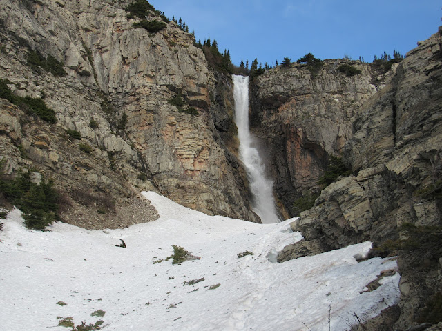 |
| A waterfall dropping into and then running under the snow |
The very next day after a night
in a free camp ground in the middle of a forest just outside Bozeman we crossed
Kings Mountain where we had a snow storm, our very first full blown snow fall.
As we descended the snow turned into rain and continued all day forcing us to
abandon our intended camp for that night as it was in a dip next to a very
swift flowing river. We found a good pull off along the highway which was
higher and much safer.
 |
| No it's not January, it's May and it's snowing |
 |
| Fun in the snow, here catch!! |
The rain cleared overnight and we
headed for Great Falls situated on the mighty Missouri River. The country side
was spectacular, this is cattle and horse country, rolling plains for miles and
miles. The Missouri River originates in the Rocky’s further southwest and
travels thousands of miles eastward connecting to the Mississippi. It also has
the Yellowstone River emptying into it along the way.
 |
| 1 of 5 waterfalls and power station in Great Falls on the Missouri River |
In the early 1800’s an expedition
lead by Meriwether Lewis and William Clarke left St Louie in the state of Indiana
(everything west of the Mississippi) and headed west along the Missouri River
looking for the infamous Northwest Passage to the Pacific Ocean. They were
stopped at the 1st of 5 separate waterfalls (now Great Falls) and
had to transport there boats up the high banks and across the land. Eventually
they reached the headwaters and had to traverse the Rocky’s by horse which were
given to them by the Shoshone Indians in exchange for trinkets and lies. After a
near death trip across the mountains they finally reached the Pacific Coast at
the mouth of the Columbia River in Oregon, where we were last year.
 |
| Chief Mountain in Blackfeet Country |
 |
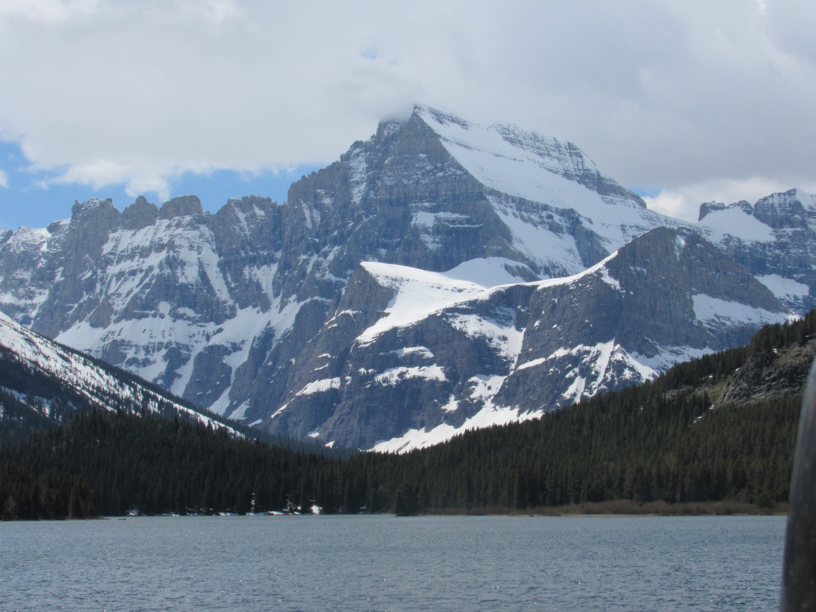
| Looking across Swiftcurrent Lake in Many Glacier |
The expedition discovered that
the local Indians had an intricate social and commercial system throughout the
country which had been functioning perfectly well for eons in balance with the
land, 25 million bison were roaming freely on the plains and 60 million beaver
in the rivers, within 80 years after the expedition the number of remaining bison
was less than 600 and beaver numbers were less than 6 million. The white
settlers not only decimated the animals they also wiped out the Indian people and
forced the remaining survivors into desolate reserves left with nothing but
their pride. Sound familiar!!!
 |
| Now entering Blackfeet Reservation |
 |
| Tipi headquarters at Red Eagle Campground |
 |
| The tipi was home to the Blackfeet Indians well before white man |
Onward north we enter into the
Blackfeet Indian reservation which is now just a fraction of its original
native grounds and lies east along the boundary of the Glacier National Park,
the most northern section of the Rocky Mountains in the USA. The Eastern side
of the park opened the day we arrived, in fact we were the first campers to
register this year at the Many Glaciers Campground. It’s located about 20 miles
along a very rough road off the byway and is amazingly spectacular with snow-capped
mountains, rapid filled rivers and placid glacial lakes some still covered with
ice.
 |
| Grinell Glacier in the distance |
 |
| Looking south along Lake Josephine |
 |
| Our camp at Many Glacier, it's a pull-through with a table and fire ring |
Being first arrivals we were
given a lecture on the dos and don’ts about park etiquette by the park ranger
and her underlings, we failed after being caught in the afternoon collecting
kindling and pine cones for our fire. Thinking were going to be given a
punishment like picking up all the chipmunk poop in the park, we got a reprieve
and let off with a warning that a critter might want to live in the pine cones
we’d collected, as if there’s a shortage of cones lying around!!! We avoided
the park police after that and spent most of the 3 days hiking the trails we
were advised not to go on and had a great time, trompsing through snow looking
for critters that could kill us. AHH!! what's life without a bit of adventure.
 |
| Snow covered trails is expected to avoid the crowds |
 |
| Lake Josephine's decrepid jetty |
 |
| Simply SPECTACULAR!!! |
 |
| A mountain goat with his winter coat, perched high up in the mountains |
 |
| A bighorn buck surveying his herd crossing the snow drift |
We had some Motorhome business to
sort out in Kalispell which is a city in Flathead County (named after the
Flathead Indians who lived here) where the RV is registered and coming up for
renewal. We headed south to the central east section of the park where a road
runs up over the mountains to the western side, however this road is closed at
present with 60ft of snow cover and only opens in July for 2 months. Called
“The Going to the Sun Road” it traverses the Rocky’s and is considered the most
scenic in the USA and we would agree even though we only travelled about a 2/3 distance
up the eastern side.
 |
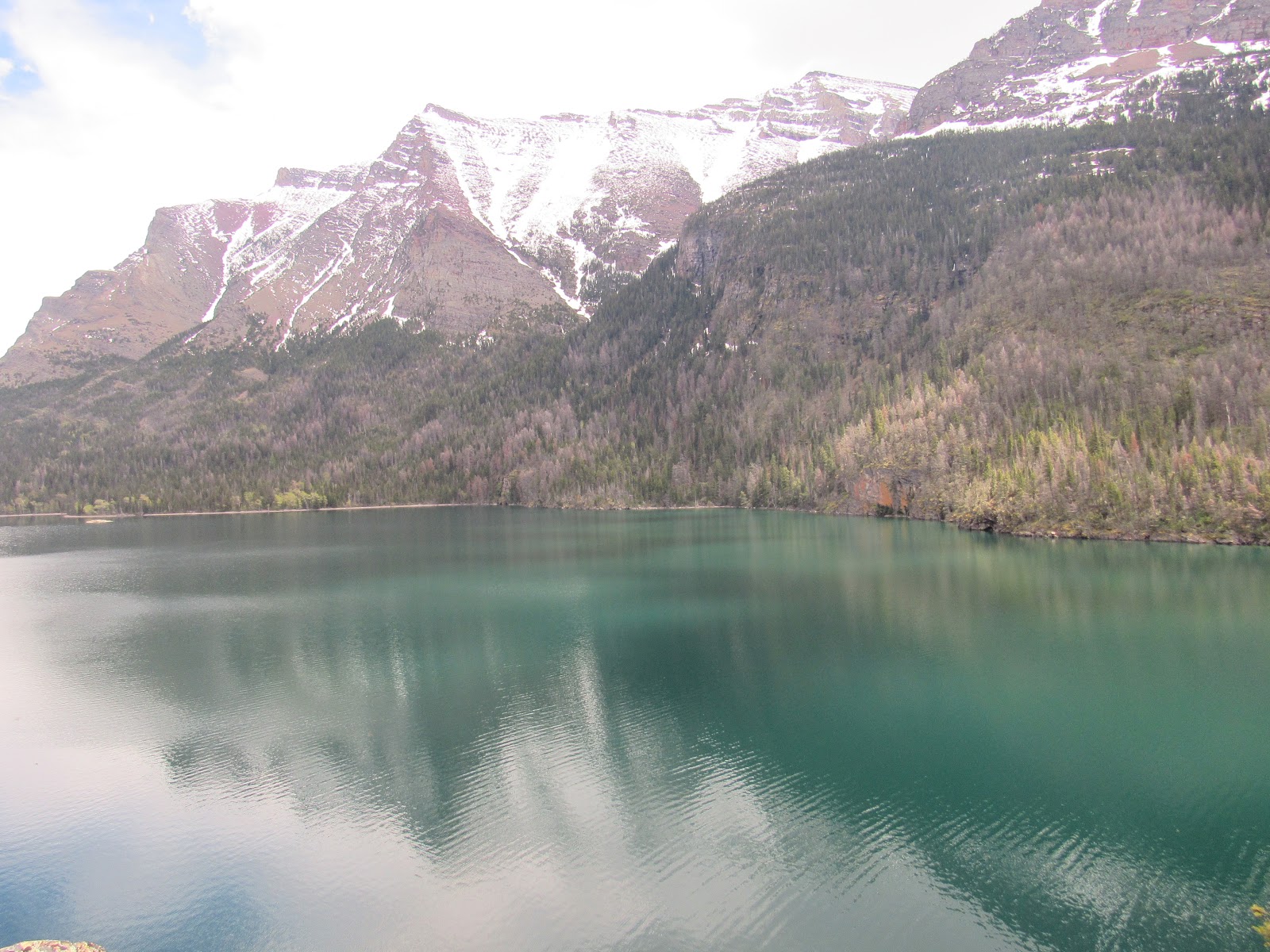
| St Mary's Lake |
 |
| Looking South across St Mary's Lake at Jackson Mountain and glacier |
Because of the road closure we
headed around the southern section of the park and camped at 2 Medicine Lake
for 7 nights, hiking bush trails like you would not believe averaging 10km per
day. We had snow a couple of nights and even 1 day while hiking for ever
thankful for our wet weather coats and water proof boots.
 |
| A hen Mallard having a bad hair day |
 |
| Cock Mallard with nice plumage!! |
 |
| A Grey Virio |
 |
| A Downy Woodpecker |
 |
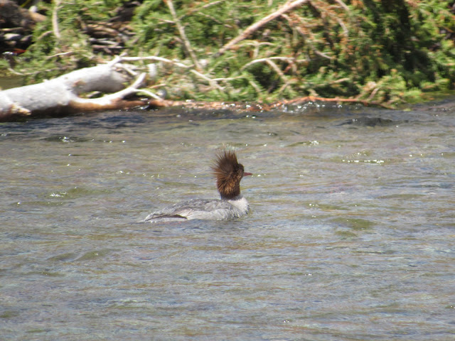
| A Barrows Goldeneye duck, certainly the weirdest looking duck we've ever seen. Here floating on Iceberg Lake |
Once around to the western side
of the park we were inundated with tourists as this part of the park is much
more commercialised. We camped at Apgar campground and drove up about 2/3 of
the Going to the Sun Road and hiked the trails. This side of the Rocky’s is
totally different to the eastern side, with much thicker vegetation including
Western Red Cedar and Hemlock trees. The eastern side is more affected by the
winter cold winds of the Great Plains. The western side being receives more
moisture and is more protected from the savage winds.
 |
| A bullwinkle moose caught along the roadside, his antlers will continue to grow all Summer before dropping again in Fall |
 |
| A couple of ever vigilant squirrels keeping an eye on the moose above |
The national park was home to 150
different glaciers in the mid 1800’s which is now reduced to just 25 and scientists
believe it will be zero by 2030 if current climate patterns persist. The
reduction is a natural process which has been occurring slowly over the last
10,000 years since the last ice age. Mankind is now hastening this process at
an alarming rate with unknown consequences yet to be determined. The remnants
can be seen in the curved shape of the canyons which have been carved out by
the ice flows and flushing rivers. The largest glacier ran west down along the
road we travelled and at one time was 30 mile long, 1,200ft thick and created
todays Lake Macdonald which is 460ft deep.
 |
| Lake McDonald looking East up the canyon created by a massive glacier which was up to 1,200ft thick |
 |
| Deer Logic: I'm standing behind a tree so you can't see me!! |
The rocks found in the park are
primarily sedimentary of the Belt Supergroup, they were deposited in shallow
seas over 1.6 Billion to 800 million years ago. During the formation of the
Rocky Mountains 170 million years ago these sedimentary layers were uplifted to
their present location. The area contains some of the oldest fossil remains of
early life anywhere on the planet. The rocks are a blend of colours mainly red
and green.
 |
| Relaxing enroute to Redrock Falls |
 |
| Little Redrock Falls |
 |
| Avalanche Lake looking North |
 |
| A deer eating charcoal to aid her digestion |
Glacier is part of a large
preserved ecosystem collectively known as the “Crown of the Continent
Ecosystem”, all of which is primarily untouched wilderness of pristine quality.
Virtually all the plants and animals which existed at the time European
explorers first entered the region are present in the park today. SEE IT CAN BE
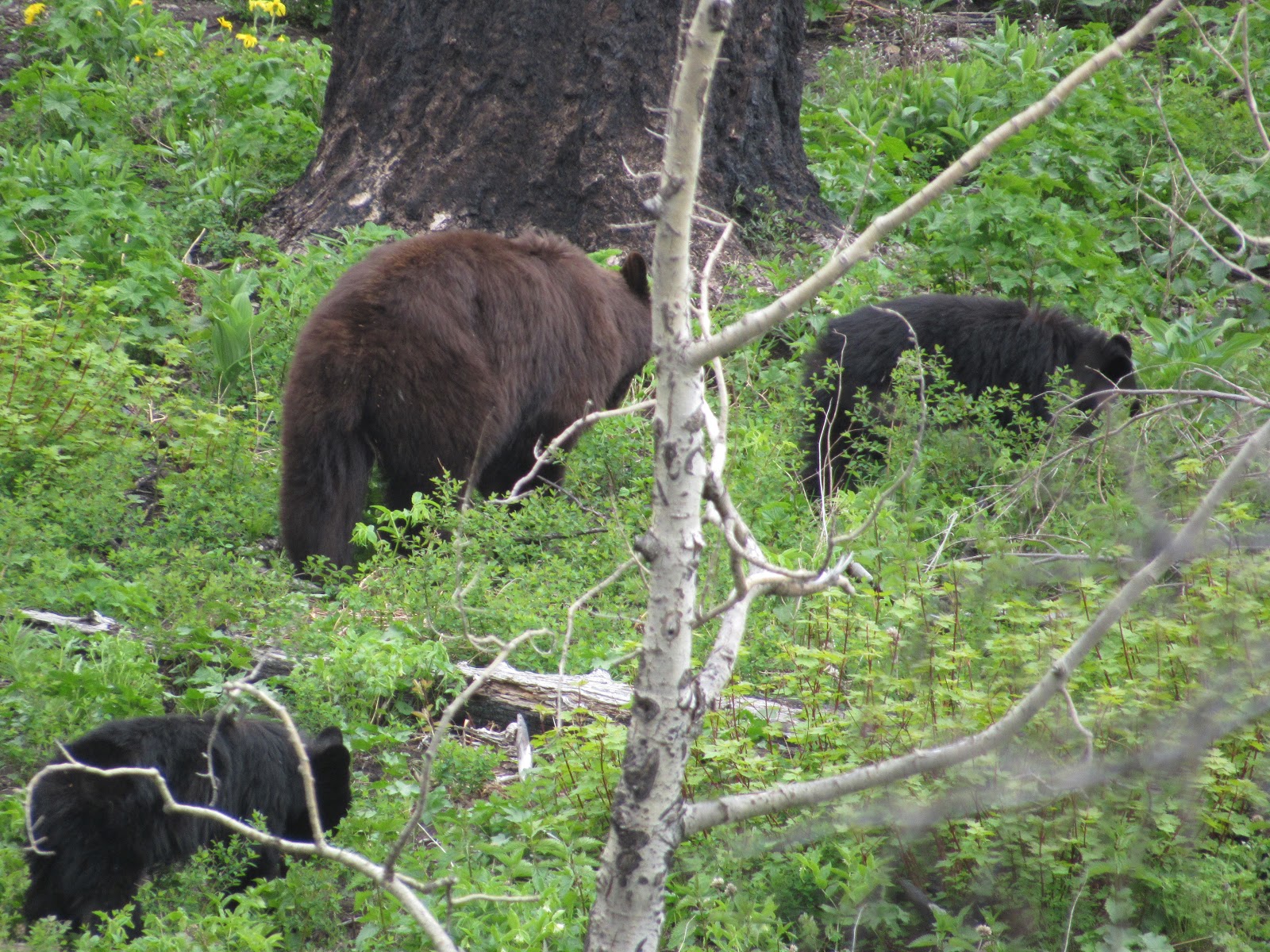
DONE!!!!!! It was estimated that there is over 300 grizzly bears in the park at
present and we have been fortunate in seeing 3 of them. In addition we have
seen several black bears, 1 with a couple of cubs, a male and female moose,
mountain goats, bighorn sheep, a variety of deer species, heaps of squirrels,
chipmunks and even a couple of splashing beavers.
 |
| A beaver who alerted us to him by beating his broad tail on the water surface apparently they do this to alert their friends |
 |
| A beaver chewed through this pine tree adjacent the river hoping it would help build his dam. Not sure if he was fined by the park rangers for wonton destruction of park property |
 |
| Our first Grizzly Bears, mum and a last years baby, both have collars for park monitoring |
 |
| Baby with winter coat just starting to fade |
 |
| Mum, you can see the distinctive hump over the forward shoulders |
 |
| Looking for food at this time of year manly flowers and grass |
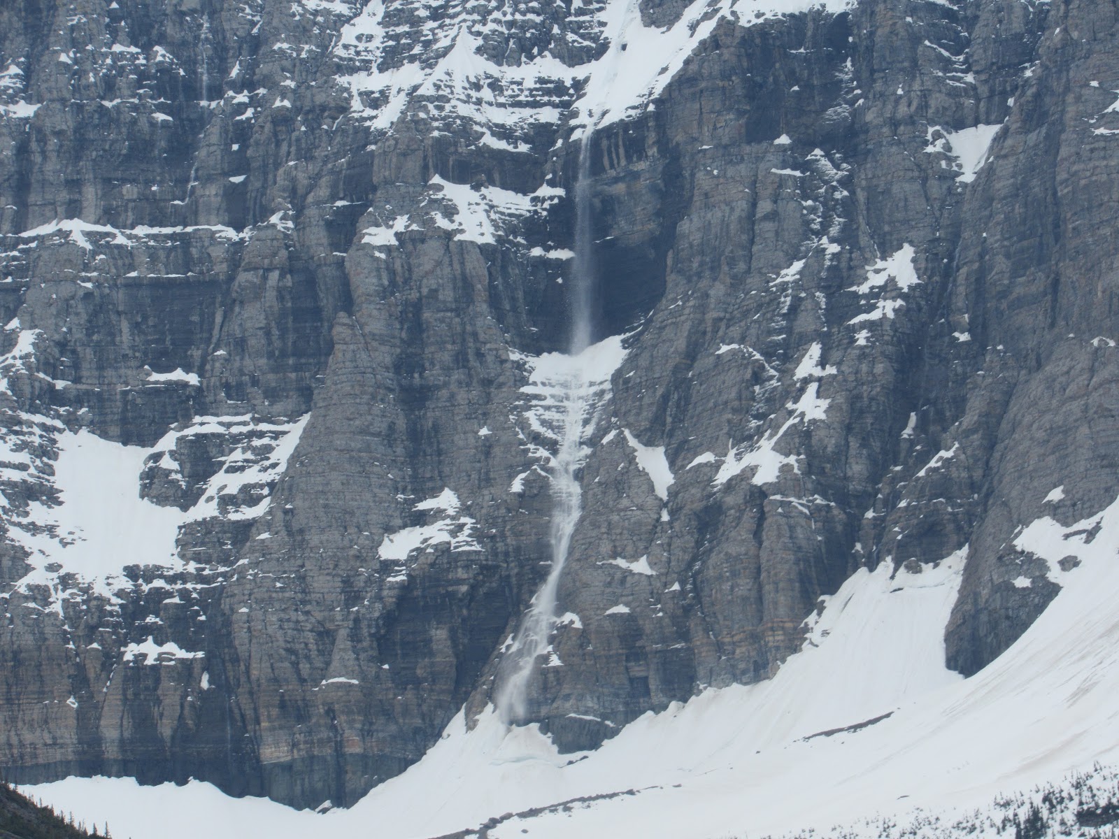
The most amazing thing we saw was
a disappearing waterfall which turned out to be a snow avalanche cascading down
a very high cliff face well in the distance near St Mary’s Lake. We traversed
several other avalanches which had ripped through the lower vegetation leaving
a trail of destruction in they’re paths. These are a common occurrence at this
time of year when the melt is well under way.
 |
| The avalanche we thought was a waterfall till it stopped flowing and started again 5 minutes later |
 |
| A mother black bear with her 2 cubs |
 |
| Mum getting a well deserved rest |
With our business completed in
Kalispell we stocked up again and headed back east around the bottom of the
park to Many Glaciers Campground again where upon entering we nearly collided
with a big grizzly crossing the road but thankfully he was quick to cross but
unfortunately too quick for us to get a photo till he was in the bush. He was
massive and we were told at the campground that he had been regularly spotted
over the past week swimming in the dam. We didn’t ask if this practice was
permitted in the local water supply or if the bears are actually allowed to
crap in the woods but did inform the ranger that all our firewood had been
legally obtained with the local Indians consent in accordance with “Best
Practice Principles” and with us being “Totally Committed” to sustainable fire
pit protocol.
 |
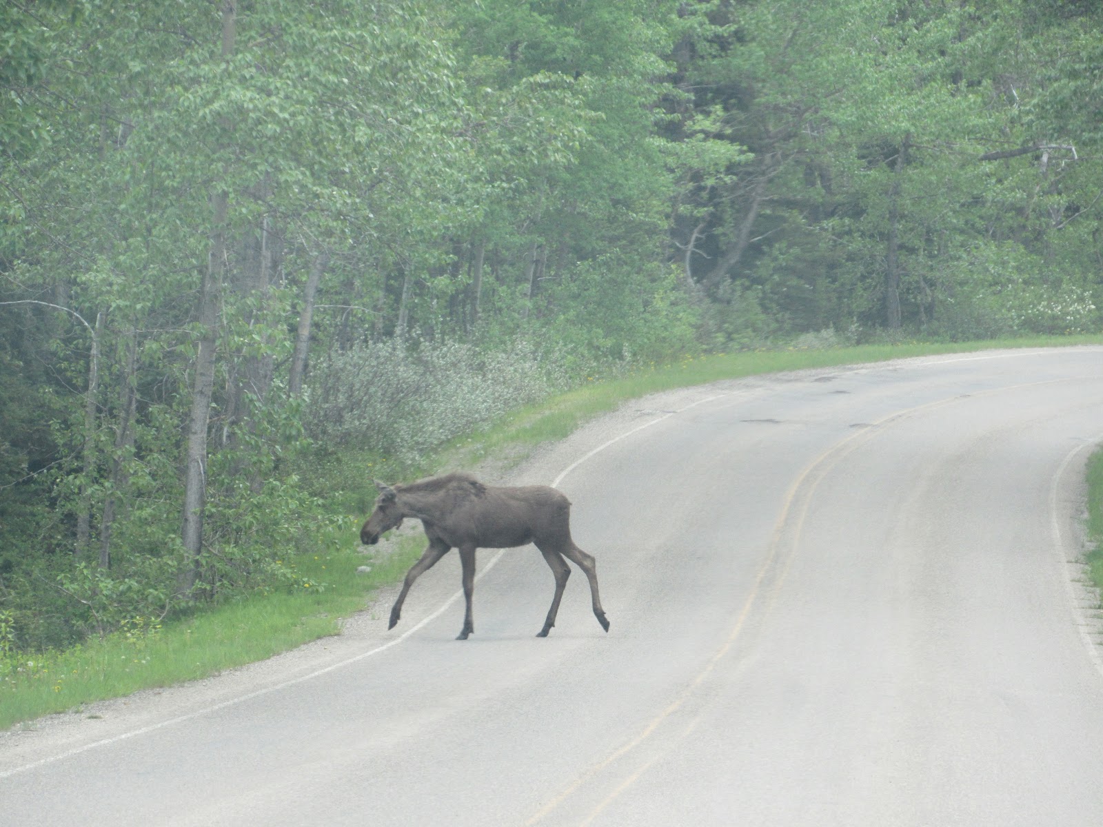
| A bull moose who surprised us along one of the many trails |
 |
| Ditto |
 |
| A young cow moose. |
 |
| Ditto passing us by |
 |
| Safely across and happy to pose |
With our improved fitness we
decided to hike a more challenging trail, 11 mile return trip up to Iceberg
Lake, high up and located just on the east side of the Continental Divide.
Again we were advised by the fun police not to go, that we would need snow
boots to get there. We went anyway as we were told by a couple we met at 2
Medicines that the view is stunning. We were the first on the trail but were
followed by about 20 others who we met on the return all eager to disobey the
authority and yes it was the most stunning trail we have ever done easily
matching if not better than the Grand Canyon.
 |
| View of the U shaped valley carved by ancient glaciers, on the way up to Iceberg Lake |
 |
| Carved out mountains forming the Continental Divide adjacent Iceberg Lake |
 |
| Iceberg Lake just beginning to thaw |
 |
| The first thaw adjacent the warming rocks we actually walked across a part of the lake |
 |
| Jen in the distance gives a good scale of the mountains and basin |
 |
| Heading back down looking across the main valley |
So far in the park we have hiked
14 trails and a total distance of 59 mile. Glacier National Park certainly
rates as our favourite place to hang out even if it costs $20 per night. From
here it’s about 30 mile to the Canadian border so just a hop skip and a jump
into Canada’s best National Parks which this year will be free as a celebration
of their 150 years as a nation.
 |
| Please sir can I have some |
 |
| AHH!! Thank you it sure is choice |
Bye For Now
Beers without Cheers as too tied from hiking
J&J