|
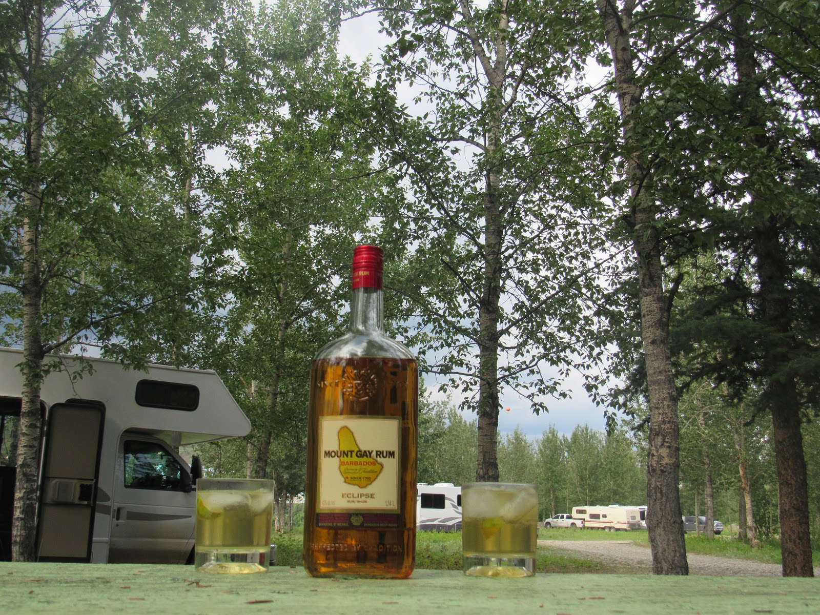
| Our entry into Alaska |
Our border crossing back into the
US was less eventful than last year’s back into the lower 48, besides this was
Alaska and you would expect a little less authority. First stop was Tok (rhymes
with smoke) to fill up, a big reprieve after Canada’s fuel prices. At US$2.84/gal
(about AU$0.90/litre) we were surprised being so remote in Alaska. In Canada at
Haines Junction our last top up we paid CAD$1.21/litre
 |
| Typical braided river bed along this part of the highway with the Alaska Range in the background |
We still had a bit further to travel
on the Alaska Highway so we moved on to Delta Junction where it ends at the
visitor’s centre after 1,422 miles not the 1,522 stated in the last blog, that
distance was to Fairbanks further along on the Richardson Highway 30 miles past
North Pole our next stop. North Pole is a quaint little town which claims to be
the home of Santa Clause and is flooded every year with millions of letters
addressed to Santa, we’ve heard that the US Postal Service is not impressed but
says it’s good for business.
 |
| Delta Junction mile post |
 |
| Santa Clause's house at North Pole |
We stopped at Fairbanks for
supplies and washing, Fairbanks was created as a temporary outpost when the
steamship carrying supplies for the Yukon gold mines ran aground. Gold was then
discovered locally and the town flourished and remained in its current location
on the Chena River which is a tributary of the Mighty Yukon which flows from
Canada across Alaska to the Bering Sea further west.
 |
| Moose antler arch at Fairbanks |
 |
| Muskox at the research centre, the white is all horn, looks like an 18th century wig |
 |
| Muskox are a very old beast which roamed around Siberia thousands of years ago |
Fairbanks is located at North 65
degrees latitude and in June and July the sun sets for about 1-2 hours per day
and that 1-2 hrs is no darker than a bright twilight. It takes a bit of getting
used to having daylight 24/7. For this reason Alaska is called the ‘Land of the
Midnight Sun’. At North 66 degrees 33 minutes which is the Arctic Circle the
sun does not set at all, close to June 22, which is the Summer Solstice. We
seriously wanted to travel up the Dawson Highway to the Arctic Circle but the
196 miles of gravel road was very bad after recent rain and not suitable for
our RV unfortunately.
 |
| Our bus which took us to the end of Denali NP and back |
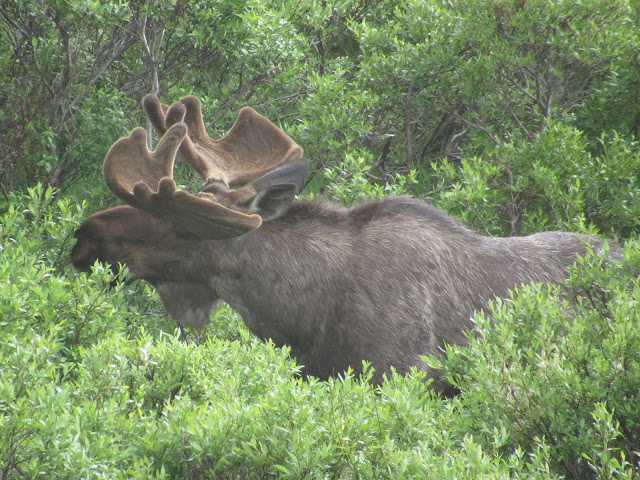 |
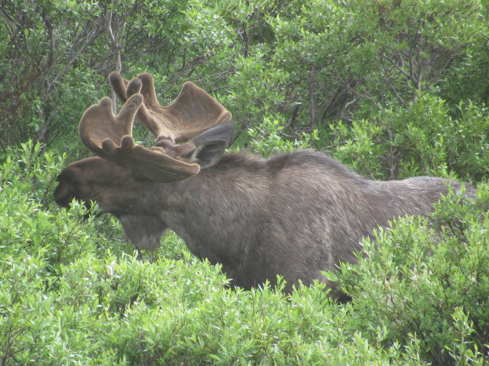
| Moose with antlers showing, they will get much larger than this |
 |
| It's amazing how the moose can carry them around |
 |
| Caribou antlers, even the females have them |
 |
| A wood caribou with new antlers and loosing his winter fur |
We headed west and then south along
the Parks Highway over to Denali National Park. Denali means “The Big One” in
local Indian and is the name given to the highest mountain in North America. We
were pre-booked into the Teklanika campground for 4 nights securing the very
last site within June and July.
 |
A snowfooted hare, in winter they are pure white all over like the one we saw at Yellowstone NP. In spring they replace their fur with a darker colour except for the hind feet. Sitting here on the road quite relaxed.
|
 |
| A red fox searching for the snowfooted hare |
 |
| The hare after spying the fox hi-tails it across the road |
This campground is located 29
miles inside the park entrance and is only accessible to those with one of 53
camp site bookings, all other tourists must catch shuttle busses every day from
the entrance. From the campground it was a further 63 miles of narrow gravel
road to the end of the park road at Kantishna. This section of park road is also
only accessible by the shuttle bus taking us about 12hrs for the return
journey.
 |
| A Denali golden grizzly bear |
 |
| And with cub |
Our first day in the park was
needed to check in and set up camp. The next was very long as we rode the
shuttle to the end and back, snapping photos of critters and the incredible
scenery. The park runs west along the Alaskan Mountain Range with Denali as a
central focus point. The sky is clear for only 10% of the time so it’s just 1
in 10 visitors that get to see the mountain. The mountain range is so high (Denali
at 20,310 feet) that snow and ice are present all year round giving rise to
some huge glaciers flowing in all directions from not just Denali, but all the
other peaks in the range as well.
 |
| A view of the valley adjacent the Alaska Range shaped out by ancient glaciers |
The gravel road through the park
winds its way up and over the alpine hills adjacent the mountain range where
ancient glaciers cut their way through the terrain exposing ragged cliffs and
multi-coloured displays of exposed rock faces.
 |
| The park road winds around these weathered hills |
The road gets quite weathered
during the winter months where temps in Alaska can drop to minus 60 Celsius and
the frozen ground (permafrost) bends and buckles creating landslides and some
very precarious overhangs, for most of the 63 miles from our campground. The
road is only wide enough for 1 bus so the outward bound bus generally pulls to
the right hard against the bank or off the road and gives way to the returning
bus so they can squeeze by each other.
 |
| Caribou on the ice it helps them keep cool and away from the mosquitoes |
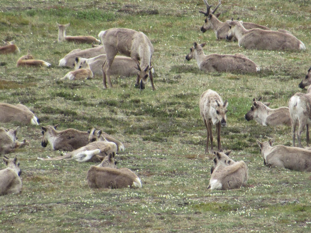 |
| Caribou herd with calves, even the females have antlers which they don't drop. A caribou is the same as a reindeer |
The drivers are well versed and
deliver an individualized detailed commentary along the way and encourage
travellers to keep a vigilant watch for critters. When a critter is spotted the
driver stops and allows everyone to scramble around inside the bus in search of
the perfect photo. A less crowded bus is an advantage for photos but to spot a
caribou or Dall Sheep takes a very keen eye so then it’s more the better. The
grizzly bears are much easier as their cream coloured fur stands out in
contrast to the low standing green vegetation. Moose are difficult as they are
mostly immobile standing in the higher vegetation, eating.
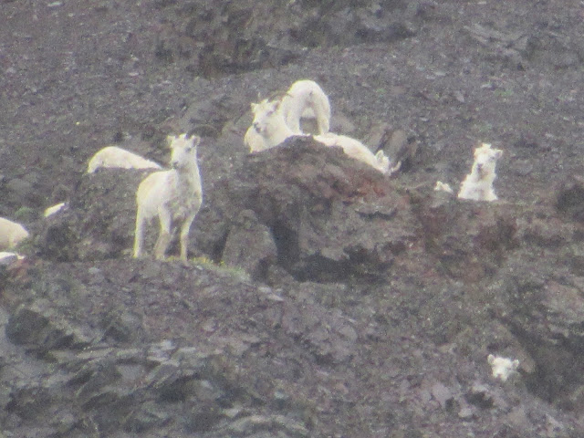 |
| Dall sheep high up on the ridgeline, ever vigilant for dangers and passing tourists |
 |
| A male dall sheep, their horns grow to a massive size |
 |
| A female moose we believe will soon give birth |
The second day in the park we
went on a ranger led hike with another 4 couples. The hike took us up over one
of the higher alpine hills into the tundra region where we experienced the soft
thick moss and ground cover plants growing like a blanket on the surface of the
hills. We saw and identified many different plant species finding that along
with the bears and other critters we too could eat many varieties. From the top
of the hill we caught a brief glimpse of the peaks on Denali albeit still
shrouded with cloud.
 |
| Hiking up over the tundra hillside |
 |
| Bluebells which are edible and do taste good |
The next morning we got up early to clear
skies and raced for an early shuttle hoping to see Denali in its glory, the bus
was tediously slow as it chugged along and of course had to stop at all the
rest areas on the way out. The bus was about ¾ full and everyone was getting
impatient with the slow progress and hoping no one spotted a caribou high on
the ridge until we rounded a bend and there in front of us Denali stood tall
and proud without a cloud. WOW!! what a sight to lay eyes on. The sheer size of
this monolith (Pluton) is unbelievable and easily equal to Uluru in grandeur.
The mountain is a single block of granite and is rising 20mm per year as it is
being forced up by the Pacific plate moving northwards under the North America
plate.
 |
Clear as a bell Denali from a distance of 20 mile zoomed in to see the extent of glaciation between north (right) and south (left) peaks which are 2 mile apart. The Muldrow Glacier between runs continuously for 30 mile down into the valley
|
 |
Denali with the park road in the foreground and a cloud just starting to form, the mountain creates its own weather systems
|
 |
| Denali towering over the mountains in the foreground |
Each year about twelve hundred
people attempt to climb Denali with less than 40% successful and some dying on
the way. It is a very difficult mountain to climb because of the narrow time
window similar to Mt Everest and the extent of glaciation creating avalanches
and open crevasse dangers.
 |
| Even at 400m away, mum still gets very aggressive towards the bus and its occupants |
 |
| Relaxed now and feeding again |
We marvelled at the sight from a
distance, thankfully, well away from its lurking dangers and searched for a
suitable place to hop off and hike. We were allowed to get off the shuttle
anywhere along the road to explore the park on our own. We were now experienced
Denali hikers and chose our location only to be denied when we arrived as a
grizzly bear was present across the road with its 2 cubs. A heap of photos
later of the bear then we were dropped off near a large lake well west of the
grizzly.
 |
| A very healthy male grizzly, dark on the rump from sitting in the wet grass |
 |
| And pleasantly strolling beside the roadway |
 |
| Mum and her little cubs |
 |
| They roam around free and easy here at Denali |
We hiked 8km down through the
tundra, across a frozen lake and then through a pine forest to the McKinley
River which runs of the main glacier from Denali accompanied by lots of
mosquitos, bugs and birds. We then waited on the roadside only to be refused
entry to the first passing bus, Jen managed to fill the last seat on the next
and I had a further 1 hr waiting and hoping for a seat on the one after that.
Eventually we got back to the RV at 8pm totally shagged, 14hrs after leaving.
We did however get to see Denali and a heap of critters so it was worth it.
 |
| Denali from the north where we hiked to the McKinley River |
 |
An Arctic Ground Squirrel they are full of beans in summer and hibernate beneath the snow during winter, a bit different in appearance to their southern cousins
|
Our final day saw us drive back
to the entrance including a short hike along the Savage River, then a husky dog
sled demonstration and talk with the head dog handler. About 30 husky dogs are
housed at Denali and used to haul supplies and equipment into the park during
winter. They are working dogs and kept fit hauling a wheeled sled around a
track during summer.
 |
| A husky hanging around in his kennel waiting to go sledding |
 |
| Eager and ready to go |
 |
| Harnessed up and ready to pull the sled |
 |
| A typical winter sled, there are several 1,000 mile races held each year in Alaska and contests are very competetive |
With our only committed booking
completed we left Denali totally satisfied with our stay, from now on we could
travel without a deadline the way we like it. We headed south to Anchorage the
largest city in Alaska and finalised some ongoing US business which had carried
over from last year. A real drag but thankfully finally settled.
 |
| Jen's message to the World, does anybody pay attention, NO!! |
Anchorage is located at the top
of Cook Inlet named after Captain Cook who discovered the area while looking
for the North West Passage in the late 1700’s well after the Australian discovery
voyage. The water in the inlet is very dirty as it comes from glaciers in the
Alaskan Mountain Range and because it is relatively shallow experiences very
high spring tides. Up to 30ft is common and the incoming tide can create a wave
that dedicated locals surf for miles. We only saw the outgoing tide and it was
neaps so didn’t bother to hang around for the change and the ensuing wavelet so
took their word for it.
 |
| Looking across Cook Inlet to the Aleutian Mountain Range |
South of Anchorage is a
peninsular with a National Park called Kenai Fjord NP which is mostly snow and
ice covered mountains with deep lakes in between and a coastline jagged with
deep ravines known as fjords. It was wet when we arrived and for all the 6
nights we stayed which is very common in summer. A local told us that at the
end of winter the vegetation is all brown and dead but 1 week later when the
ice begins to melt the area turns into a lush green paradise. We had to agree
we have never before seen so many vivid shades of green all contrasting with
each other and with the remaining white ice capped mountains and glaciers.
 |
| Exit Glacier near Seward on the Kenai Peninsula |
 |
| Exit Glacier close up, the dude lying down fell from where his mate is. OUCH |
 |
| Exit Glacier face which is retreating rapidly every year |
The Kenai Peninsula road runs
south for about 150 mile to Homer which is the sea port for ferries running
south to the far stretching Aleutian Island chain and a very popular fishing
location. We landed at Homer for the Independence Day weekend and despite the
crowds, rain and fog enjoyed the place as a good change from the interior and a
chance to breathe salt air again. We hooked into a local fish delicacy called
Halibut, a flounder looking fish which can grow to a massive size in excess of
400lb.
 |
| Looking across Kachemak Bay at Homer on the southern tip of the Kenai Peninsula |
 |
| A bald eagle posing for us at the end of the Homer Spit |
 |
| Close up, and a profile thankyou! |
The Halibut starts life as a
normal swimming fish with one eye on each side then as it grows one eye rotates
to the other side with the mouth moving underneath and the fish adopts a bottom
feeder life living in very deep water (200m plus). The fishing tackle required
for the big fish is massive and fishing these freezing cold waters requires an
additional determination. There were plenty trying, but we’ll stick to our
tropical Coral Trout any day thank you very much!!
 |
| A Halibut replica, over-rated as far as we are concerned |
 |
| Amazing blue flower |
 |
| Another wildflower |
Our backtrack from Homer took in a detour to Skilak Lake and a 6 mile round trip hike through the scrub and fields of wildflowers. We caught sight of more bald eagles, a scrub grouse which resembled a guinea fowl and again thankfully on the road a black bear family, this one with 3 cubs.
 |
| Mum and 1 cub |
 |
| Mum alone |
 |
| Another cub heads back across |
 |
| Then the other two decide to head back across, a bit like the Abbey Road album cover |
Rather than head all the way back
to Anchorage and east along the Glen Highway we decided to take a shortcut by ferry from Whittier another seaport on the Kenai
Peninsula across the Prince William Sound at the top of the Gulf of Alaska in
the Pacific Ocean to the infamous port of Valdez.
 |
| A Scrub Grouse, cousin to a Ptarmigan |
 |
| A bald eagle perching high up on a very small branch |
 |
| Not a happy chappy sitting so high but he has a good grip with those talons |
Firstly we had to travel through
the second longest tunnel in North America 2.5 miles under a glaciated mountain.
The tunnel is only one vehicle wide and also includes a centrally aligned
railway track. The railway runs all the way from Whittier to Fairbanks in the
north via Anchorage and Denali NP.
 |
| A glacier coming down close to Whittier Bay |
 |
| A distant glacier reaching the waters edge |
The ferry trip took 8hrs and
traversed many islands along the way. From the ferry we could see huge glaciers
reaching down from the mountain peaks towards the sea and waterfalls spilling
for hundreds of feet. We caught glimpses of sea lions perched on rocky
outcrops, sea otters lazily floating by on their backs, dall dolphin bobbing at
the surface and several orca (killer) whales cruising past, dorsal fins
displayed well out of the water.
 |
| A Sea Otter relaxing on his back as we pass by |
The view was spectacular and the
weather was perfect. Surprisingly there was no Pacific swell at all for the
whole trip, it all being blocked by the large southern islands of the sound. It
would be an ideal cruising ground in summer providing the gales stayed away,
shallow water anchorages could be found and of course the temp would have to
rise a lot, currently maxing at 13 Celsius.
 |
| An Orca (Killer Whale) passing by |
Enroute to Valdez we passed Bligh
Reef, named by Cook on his northern discovery voyage after his 1st
Lieutenant William Bligh well before the famous mutiny, ironically it was this reef
that the oil tanker Exon Valdez struck on Good Friday 1989. The ship leaked a
massive 10.8 million gallons of crude oil into the sea covering 11,000 square
mile of ocean and 1,300 miles of Alaskan coastline killing huge numbers of bird
and sea life, which hasn’t fully recovered yet!! The largest preventable environmental
disaster ever.
 |
| Bligh Reef light in Prince William Sound where the Exon Valdez struck |
The Captain was drunk and the 3rd
mate was in command. The ship’s radar was not working and reportedly had been
broken for the previous 12 months. The ship was not supported with any tug
protection, surprising since the port was only 10 mile away. It is now
compulsory for all ships to be escorted by 2 tugs all the way to the clear
water marker outside the southern islands of the sound.
 |
| King Salmon schooling prior to returning upstream |
 |
| A Sea Lion feasting on the King Salmon in Valdez Harbour |
Again on Good Friday but in 1964
Valdez suffered a severe earthquake which caused an underwater landslide with a
section of the shoreline breaking off and sinking into the sea creating a 30ft
high Tsunami travelling away from the city. All 32 people loading the transport
vessel SS Chena were killed when the dock collapsed. Valdez is a beautiful
natural harbour with cascading waterfalls tumbling down from adjacent glaciers
but is definitely not a good place to visit at Easter.
 |
| A majestic waterfall cascades down the cliffs in Valdez Harbour |
Valdez is also the end location
for the huge Trans-Alaska oil pipeline which crosses Alaska from North to South
about 1,000 mile long. It requires 12 separate pumping stations for the journey
and was an incredible feat to achieve in just 2 years between 1975 and 1977.
Most likely non profitable these days as oil prices continue to plummet. There wasn’t
any tankers in port while we were there, a sure sign that commodities just like
gold which created a frenzy over a century ago in this region all have a
limited demand when alternative sources can be found.
 |
| Valdez Harbour with the mountain landscape behind |
Following the route of the
pipeline along the Richardson Highway we headed north out of Valdez through
Keystone Canyon, over Thomson Pass and on to Worthington Glacier all
spectacular sights seen beside the highway.
 |
| A coy black bear caught near the campground in Valdez |
 |
| The bins are bear proof and stop this guy who is obviously very persistent and perhaps hooked to human food |
We took a detour East along the
Kennicott road to the Copper River which is a massive river draining south into
the Gulf of Alaska. The water flows from Glacial Ice melt in the mountains
which are part of the Wrangell - St Elias National Park. These mountains form
the western part of the massive icefields which includes Mt Logan described in
the last Canada blog.
 |
| Waterfall in Keystone Canyon |
 |
| Worthington Glacier adjacent the Richardson Hwy |
Here fishing is only allowed for
local indigenous using rotating fish wheels which seems very unfair to the fish.
However it is the only way to catch these fish as the water is so dirty, fast
flowing and they can’t see a lure or won’t take a bait. The locals also use huge
dip nets to catch passing salmon as they migrate up stream. The salmon are
quite big and the practice is very dangerous as the net holder can be swept
away by the swift current never to be seen again.
 |
| Chitina obviously had a more glorious past |
 |
| The Copper River, look in the left bottom corner for the eagle sitting on the log |
 |
| To catch fish here one requires a very good eye similar to this guy |
Further north and another detour east
along yet another gravel road for a hike into the mountains within the national
park. We hiked along Caribou Creek Trail for 3 mile to a hut, through low
valley tundra, then a forest of spruce pine, alder and willow interspersed with
loads of wildflowers.
 |
| Mount Sandford in the Wrangall - St Elias Mountains |
 |
| Fireweed a very common wild flower |
 |
| More wildflowers |
No critters unfortunately but we
blame this on the fact that hunting is prevalent in this park by indigenous,
supposed to be traditional but we doubt this, as they use spotting planes,
ATV’s and rifles, nothing traditional about that. The park ranger just shrugged
when quizzed. We did however see a moose with calf at the local school when we
returned to the highway, obviously the safest place to raise offspring. Unless
of course the children can hunt at playtime, which here in this country would
not surprise us at all.
 |
| Domesticated Alaskan Oxen |
We arrived back in Tok to
complete the circuit with just 2 gallons (about 20 mile) of fuel left. I
refused to pay the ridiculous prices wanted along the highway from Valdez after
filling up at the Kenai Peninsula. Despite Jen’s concern I informed her it was
all calculated that way even the detours. We saved a heap filling up in Tok
where the price had dropped from our previous visit to US$2.69/gal.
 |
| A typical 1800's Alaskan log cabin with bear proof storage locker |
From Tok we headed north along
the Taylor Highway to a small town originally named Ptarmigan (with a silent
P). The town was named after the local scrub fowl which were plentiful during
the gold rush but not now. The original name was only used for a short period
because very few people could agree on how to spell it so the town was renamed
Chicken because the Ptarmigan looked and tasted like chicken and everyone knew
how to spell CHICKEN. As an aside, they didn’t want their town name ridiculed
for not being spelt correctly – go figure??
 |
| The big chicken at Chicken |
 |
| Sign post at Chicken showing distances to other places in the world with similar fowl names |
It poured rain in Chicken and the
through road was having a major renovation along with a new bridge so we left
heading for a campground further north along the decaying highway which was all
gravel and very wet. We found the campground closed and had been for nearly a
week due to a recent grizzly bear encounter and of course a barrier blocked our
way. We just camped at the entry, thankfully nobody came to harass us.
 |
| Main street of Chicken |
The next morning we continued the
drive to the border crossing check point along the start of the “Top of the
World Highway”. This highway runs into Canada along the ridgeline of the
North/South Divide and I’ve got to say it we were feeling “On Top of the
World”. YEE HAA!!
 |
| 80 mile of horrible dirt road and then 10 mile of this wonderful new bitumen road at the start of the Top of the World Highway to the Canadian Border |
Bye for Now
Beers and Cheers at midnight in Alaska without US!!
J&J


