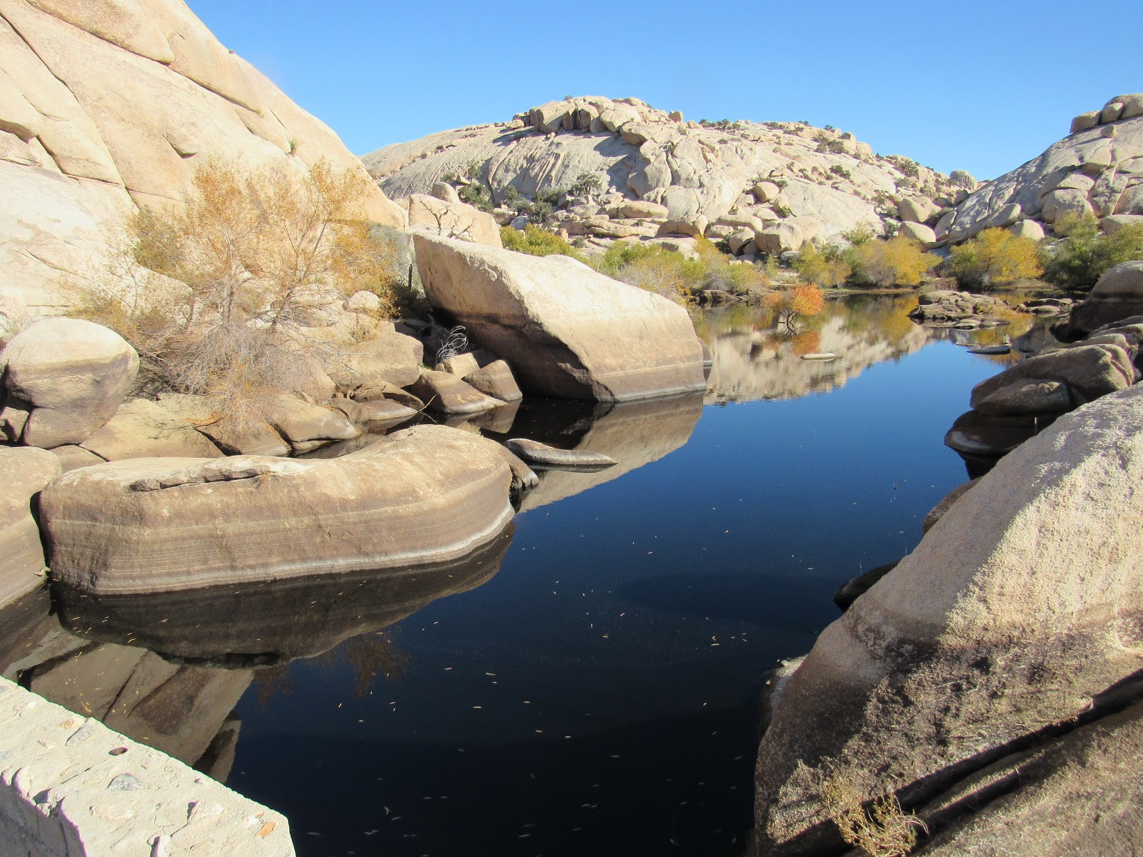
The Rocky Mountains National Park
is another of the famed parks which we were expecting great things from, but
similar to Yellowstone we were left wondering what’s all the fuss about. It's probably just a great place to hang for a while and soak in the scenes.
 |
| Looking east back down the valley in Rocky Mountain NP |
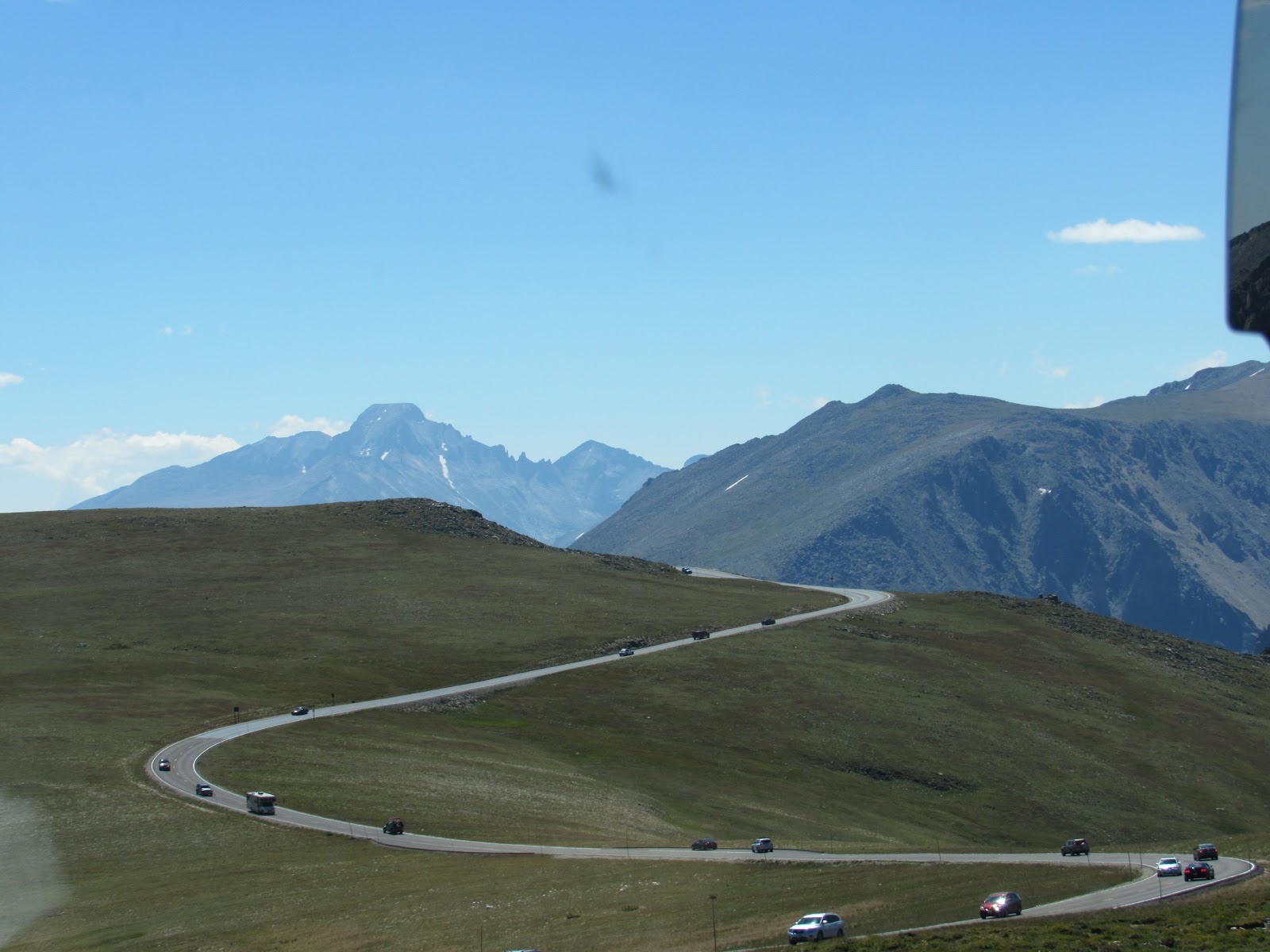
The mountains are spectacular and
the park contains some of the highest peaks in the US but like Yellowstone it’s
commercialised and crowded, perhaps in Spring or Fall it may be better. We just
don’t do crowds.
 |
| Looking south from near the highest part of the Ridge Trail |
Many areas within the park are
only accessible by undergoing extended hikes for many miles or you’re left with
just a drive-thru along the very scenic Ridge Trail Road which takes you across
the mountains from East to West or vice versa depending on your destination.
 |
| High up above the tree line the road continues with all and sundry |
The Ridge Trail climbs to a pass in
excess of 12,000ft, high above the tree line and into the most southern tundra
in the Northern Hemisphere, spongy moss and stunted growth just like we saw in
Alaska’s Denali NP.
 |
| Our highest moment at over 12,000 feet |
We found a camp in the National
Park campground on the western side adjacent the head waters of the Colorado
River. Here it is just a creek before it heads southwest for 1,450 mile collecting
water from other rivers along the way.
 |
| In winter this valley has about 50 feet of snow cover and is uninhabitable except for the hardiest of creatures and plants |
 |
| Looking westward amongst the pine forests which are being attacked by boring beetles, digging not dull |
A little further west we stopped
a night in a free camp at Hot Sulphur Springs also on the banks of the Colorado
snagging the last of only 11 sites. The name sounded interesting but again we
were left wondering, what’s the attraction here?? as a lap around town revealed
nothing other than a railway line within 50m of the camp. At least 6 trains
blasted their horns during the night as they approached the adjacent road
crossing giving us precious little sleep and a grumpy start to the new day.
 |
| A beaver pond and many dead pine trees in the background |
 |
| The Colorado River at its headwater, just a stream here |
 |
| Down stream about 30 mile and the Colorado starts to take shape |
Again we headed west and managed
to free ourselves from both the Colorado and its accompanying railway and found
a camp on the Green River at the Dinosaur National Monument which lies on the
border with Utah. The monument is a combination of a live dinosaur dig quarry
and back east the Green River Canyon. The Green River is the main tributary of
the Colorado running for 730 mile itself from Wyoming in the North to the
junction in Southern Utah.
 |
| A baby Osprey caught crying out for more |
 |
| A curious white tail prairie dog near Green River Canyon |
We were advised not to miss the
canyon so we headed back to the eastern end of the park 75 mile away along the
road we had come the previous day. We were also told of the solar eclipse which
was to occur that day at 1130 and given a couple pair of eclipse viewing eye
covers. Our location was expecting 91% of sun cover by the moon as it passed
between the sun and earth.
 |
| Looking east the canyon is breathtaking |
The eclipse was amazing as we
hiked along the trail out to the canyon, the sunlight dulled, all was quiet and
it got quite cool, even the shadows become fuzzy. With the eye covers we could
easily see the moon crossing and were very surprised that even at 91% the
amount of light still present. The last solar eclipse in the US was in 1978 so
it’s been a long time between events.
 |
| Watching the solar eclipse |
 |
| The shadows became quite fuzzy creating feather like shadow rather than crisp definition. Many people noticed this peculiarity |
 |
| The canyon when the sun was almost blocked out |
The Green River Canyon was
spectacular displaying the many rock layers which the river has carved through
over the millennia. Rock layers which have been bent and buckled with pressure
as the plateau rose 4,000 feet when the Rocky Mountains were thrust upwards. As
the plateau rose the river continued its course cutting the canyon rather than
divert around the uplifted area similar to the Colorado River and the Grand
Canyon.
 |
| Full sunshine again and the canyon shows the extent of buckling and swirling erosion over the millions of years |
 |
| The curved formation required huge amounts of pressure from below to bend the layers here, a fault line also exists running across the river and up the valley in the bottom left corner |
 |
| Looking westward the river is 4,000 feet below the plateau which was once below sea level |
 |
| The Green River is green because of the sunlight reflecting off the sediments suspended in the water |
The western section of the park
was amazing, to see a live quarry excavation with masses of dinosaur skeletons dating
back 150 million years. The area was once at sea level where the dinosaurs
lived and it is believed that many died in the muddy swamps. Their entire
carcases were buried below silt layers preserving them as fossil remains.
 |
| A rainbow of exposed colours depicts a time line over 150M years |
 |
| This rock is the oldest about 750M years and hardest in the park, it appears to have been drilled with a huge auger while in fact it has been carved by the Green River whirlpooling through the canyon |
 |
| A Stegosaurus replica, these dinosaurs were well represented in this area |
 |
| These dinosaurs were present in this area during the Jurassic Era and now found as fossils below the hills |
 |
| Awesome creatures that ruled the world from 150M - 50M years ago |
 |
| These creatures laid eggs and were warm blooded more like birds than reptiles |
 |
| Lower jaw of a Tyrannosaurus Rex, old and broken teeth were renewed when needed just like sharks |
The uplift of the Rockies twisted
the landscape at 60 degrees and after eons of wind and water erosion exposed
the sedimentary layers bringing the fossils to the surface and just below.
 |
| Embedded in stone this dinosaur was a meat eater |
 |
| The rear socket is for eyes while the others are air sacks like sinus |
 |
| The teeth are perfectly preserved in the stone |
The Dinosaur National Monument
and its campground were fantastic along with the rangers who were very helpful
and knowledgeable, a great place which just happened to be on our westward
passage. Another unplanned visit which paid off, we spent 3 nights here and loved
the place.
 |
| A perfect backbone showing the interconnecting vertebrae |
 |
| Femur bone from a Brontosaurus, a massive vegetarian dinosaur |
In Utah now and again heading
west, we are in the last month of summer so need to keep above 5,000 feet to
keep cool, we cut south of Salt Lake City and find a roadside camp on a summit
at 6,500 feet. The deep salt valley we crossed was once full of water prior to
the mountain collapse further north causing a surge in the adjoining Snake
River carving its valley which we saw at Shoshone Falls earlier in the year.
The Great Salt Lake is huge and a great reminder of the forces which play in
the creation of these marvellous landscapes.
 |
| Petroglyphs from 10,000 years ago when the first Fremont Indians arrived in the more fertile region |
 |
| How many lizard petroglyphs can you find on this rock face |
Across another valley and border
we are again in Nevada and pulled into the Great Basin National Park thinking
that we just crossed the “Great Basin”. We were thankfully informed that the
Great Basin in fact covers an area in excess of the state of Nevada, half of
Utah, north to Idaho and west to the White Mountains in California. We developed
a much better appreciation for Nevada now, knowing that the basin is in fact
defined as the area where water that falls as rain and snow does not reach any
ocean.
 |
| Wide open plains between the mountain ranges used to be much more fertile than they are today and will become more arid as time goes by |
 |
| Rock Glacier has almost fully receded and will soon only appear during winter |
The mountains in this region were
created when the plateau rose and buckled causing ridges up to 13,500 feet and
valleys down below sea level. They formed in a north/south orientation and
somehow not a single river was able to find its way out.
 |
| This tree is 5,000 years old commencing its life before the construction of the Egyptian Pyramids |
 |
| This Bristlecone Pine is twice as old as Jen, so how old is that, well I'm not saying |
The park surprisingly has an
active glacier which we hiked to and a Bristlecone Pine forest with trees 5,000
years old. It is also home to Lehman Caves which are limestone formations
carved out by water accessing the limestone layer well below the mountain
peaks. It was another great find and gladly free of the masses. An oasis in the
desert!!
 |
| Amazing caves |
 |
| A little squeezy |
 |
| Spectacular!! |
 |
| Phenomenal structures like these abound within the depths of these caves |
 |
| The caves are only fully appreciated with good lighting something which was not present when they were discovered in the 1800's |
 |
| The early visitors to these caves were pioneering people who thought it good to leave their marks and take souvenirs, many sad reminders remain within the confines of the caves |
 |
| This creature is 1cm long and is considered the lion of the caves, very few things can live in the perpetual darkness, some come to sleep but very few to eat |
We hit our outbound junction at
Tonopha in western Nevada and avoided backtracking by using an alternative
route around the White Mountains and arrived again at our favourite camp (3rd
time), Alabama Hills at Lone Pine, California, just below Mount Whitney in the
Sierra Nevada Mountains. It’s a Luna landscape at 4,300 feet and despite the
heat is a great camp away from any other campers.
 |
| Our very own Stone Henge |
 |
| Close to twilight the adjacent mountains almost glow |
The next day we visited the Mt
Whitney trailhead up the road at 8,500 feet and spent the day keeping cool
before returning to our camp location. We considered the climb but found out
that we needed to book 12 months ago, it’s very popular due to the short window
available in summer only. The trail attracts people from all round the world
and gets you to the peak at 14,494 feet and back after hiking 22 mile round
trip elevating 6,000 feet. A bit more than our usual day hikes.
 |
| Mt Whitney peak with the last remnants of snow, much changed from our earlier visit in April |
With a week to go before storing
the RV in Bakersfield again and flying back to OZ we climbed the Sierra Nevada
Mountains from the east along a very precipitous road we avoided last year due
to bad wildfires in the region. We found a campground at 7,500 feet and despite
the horrendous thunderstorms we endured comforting temps in the range of 25 – 10
Celsius instead of the 45 – 30 Celsius currently in Bakersfield.
 |
| Tucked up in the Alabama Hills |
It was very pleasant for the
couple of days before descending down to 450 feet at Bakersfield and the
Southland RV Park. It’s hot but we need to get sorted so we cranked the AC up
full bore to cope.
 |
| A woodpecker making hard work on a Ponderosa Pine |
We have again had a fantastic 4
months exploring the best this continent can offer and seen some incredible
places and wildlife in the short time, travelled nearly 15,000 mile. We will
return next year in the northern winter and head south to the deserts, maybe
even Mexico and beyond. Fools and their walls a hinder to no one.
Fly For Now
 |
| Beers and Cheers from the Santa Monica Windjammers Yacht Club doing lines of coke as we wait to get high again at LAX |
J & J


