Blog No 3
We must have been drawn to this location in Flagstaff, our
free camp is located on the Naval Observatory Road just off the old Route 66
and down the road from the Lowell Observatory which discovered the planet Pluto
back in the 1930’s. A great camp amongst the glistening stars, and the
Ponderosa pine trees, warm during the day and cool at night. All day there is a
scurry of activity with our little squirrel friends looking for food to fatten
up before winter returns.
 |
| Home among the pine trees, no fires this time due to a burn ban |
All’s good with our RV rego, we sent the documents away on
the Wednesday and we collected the plates on the Friday morning, now officially
registered in Montana and ready to roll, great service couldn’t ask for better.
Each year our agent collects all the paperwork necessary for registration and
insurance renewals, all we do is pay via the internet and access the paperwork
via a website portal.
 |
| Cotton Socks filling his belly on our vegi scraps |
 |
| Struggling to get home after a big feed |
 |
| A ground squirrel takes over but missed out on the carrot |
While in Flagstaff we set up an additional 12 volt power
system to provide power from our house battery directly to charge our computers
and camera battery. This will supplement the inverter we installed back in
Cedar City a week ago which has been running off our main engine battery. The
inverter is fine while the engine is running but too big a power drain when we
are idle.
 |
| A team of Giant Tortoises in a huddle to see who's going to kick off |
Now that all was in order we decided to head west towards
California hoping to make our fortune like all the old pilgrims in the 1800’s.
First stop is a town called Kingston, Arizona which like all American towns has
to have its own claim to fame. This town’s claim is that it was home to a
person called Andy Devine. Sam informed us of this because every second street
is something or other ending in Andy Devine. Totally ignorant we head for the visitors
centre, which just happened to have a museum honouring, yes you guessed it A.D.
If you’re currently in your 90’s you might recall a silent movie star called
Andy Devine who played a cowboy, other than that it’s just a yawn!!
 |
| Arizona gives us the finger just before crossing the Nevada border |
We move on quickly before we die of boredom and head down
our first of many canyons to the Colorado River which is the border between
Arizona and Nevada, it’s a playground in the desert and probably the only place
in the world where jet-skis are the best suited marine craft. The river flows
so fast you can’t swim against it and any journey downstream other than in a
motorised craft would require a tow back. So if your jet ski breaks down you
end up in the Gulf of California, 500mile away, ahh who cares!! The water is
cool and the desert wind is stifling, we dip our toes and decide to move on.
The Colorado elevation here is about 500ft, well below the 2,300ft within the
Grand Canyon, thanks to a couple of dams in between.
 |
| The fast flowing Colorado River is a playground in the desert for many |
We parked up for a warm night at a turnout along the Joshua
Tree Hwy on the edge of the Mojave Indian Reserve in the middle of nowhere,
somewhere in southern Nevada, we saw the glow of Las Vegas in the distance and
listened to the coyote’s calling each other during the night. Felt just like
the old timers camping out, but a whole lot safer inside a locked RV. The desert
flowers and cactus are just beginning to bloom and make a lovely sight amongst
the weird looking Joshua Trees.
 |
| Our camp for the night during our brief Nevada stay |
 |
| Joshua trees scattered all over the desert, but only in some areas, their seeds used to be spread by giant sloths, but since its extinction and climate change the tree numbers are dwindling |
 |
| The Joshua tree is a member of the Yucca tree family and seems to be a cross between a pine and a cactus, quite strange looking and very slow growing, less than 100mm per year which for desert standards is quite fast apparently |
The next day was a big one, we’d made the choice to head
northwest for our entry into California rather than southwest through the
deserts and this meant we would need to cross “DEATH VALLEY” in the middle of
summer, OUCH!! Hey, could it be any worse than Phoenix?? Our aim was to endure
the heat during the day and then hopefully find a cooler place close to the
Sierra Nevada mountain range by evening.
 |
| Baker's claim to fame was that the Mars Curiosity Rover Robot was tested here prior to it's space journey thus making everything ALIEN. Now that takes the cake, or jerky in this case. |
First we skirt around the northern side of the Mojave Indian
Reserve then heads north along a lonely road to Shoshone, a town named after the
local Indians that lived in the area. Next it’s onwards towards Death Valley,
but the southern access road is closed unbeknown to Sam so we have to continue
North to the Eastern access road.
 |
| This guy refused to pay first for his gas |
Death Valley was amazing and thanks to a cloudy day meant
the temperatures were about the same as Phoenix 45C. The world record is 57C at
Furnace Creek in the middle of the valley. The lowest point at the southern end
of Death Valley at Badwater Basin is 282ft BELOW sea level and what would
appear to be a lake from the distance is in fact a salt bed shimmering like a
mirage to the unknowing traveller. The valley itself is again another WOW!! The
cliffs around are sheer with an assortment of different coloured formations
changing with every bend in the road. We have to backtrack a bit because the
Southern access road was shut but by doing so we saw things we missed on the
first run.
 |
| Death Valley is an awesome place with moon surface like features everywhere. A very inhospitable place for any form of life |
 |
| The lowest point in the US and a record for us. Lake Eyre in OZ is about 60 feet below sea level. |
 |
| It would appear that people are walking on water but in fact the whole area is a salt lake |
 |
| Water does lie beneath the surface but not a drop to drink |
At the northern end of the valley we found sand dunes with
sand being whipped up by the southerly wind like a storm you’d expect in the
Sahara Desert. We climbed out of the valley along a narrow winding road up to a
height of about 7,000 feet before descending again down into another valley
with a base at about 1,000 feet and more sand dunes again whipped up into a
frenzy, where it was difficult to see the road ahead.
 |
| It's called the Artist's Palette, a coloured mound formation resulting from various chemical crystals leaching out over the millenia |
 |
| Just when we think we've seen it all we get the 30ft high sand dunes you would expect in the desert. |
 |
| The valley below is whipping up a sand storm which we have to drive through to get out |
 |
| Leaving Death Valley behind, a desolate scene, don't know how they crossed it on horseback, we virtually drank our RV dry |
After another climb up to about 7,000 feet we then descended
down into yet another valley to about 2,000 feet with the most magnificent mountainview
to the west. The Sierra Nevada Mountains is a sight to see, especially from the
Eastern side and what we saw first was Mount Whitney 14,491 feet the highest
mountain in the US lower 48. In one day we saw the lowest point and the highest
point in the US both within 150 miles. The Sierra Nevada Mountains still had
snow on top even in the middle of summer. AMAZING!!
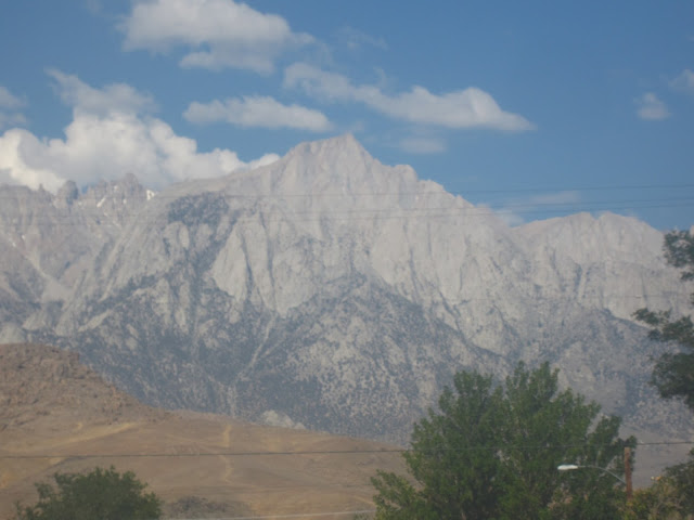 |
| Mount Whitney, an awesome sight on a clear morning |
Levelling out at about 2,500 feet we searched for a free
camp in a town called Lone Pine. The town is famous for all the western movies
which have been filmed here over the years. We find a campsite in the Alabama
Hills just behind the town, at the foot of Mount Whitney. The hills have
distinct boulder formations and contrast with the adjacent mountains, a perfect
backdrop for the films that were made, some of the formations look vaguely
familiar. Meanwhile back at the RV a jack rabbit scared Jen, while she was checking
out the boulders but it was too quick for us to get a shot, camera shot that
is.
 |
| The Sierra Nevada Range was formed after a succession of massive uplifts and plate tilting episodes, most is granite carved away by glaciers over millions of years |
Elevation here in California is an important gauge of
temperature for both day and night. It’s hot down low and cool up high. We’ve
found that 4,000 – 6,000 feet is a good height at night and this works well
with the pine tree forests as well. Daytime doesn’t really matter as we are
travelling most of the time, except while hiking then it’s plenty of water all
day long.
 |
| Looking for the best campsite in amongst the Alabama Hills, Lone Pine |
 |
| With storm clouds brewing we settle in for a quick beer. Alabama Hills is the remains of ancient glacial flows coming down from the Sierra Nevada Range behind |
We were going to head south to the Sequoia National Park and
then onto Kings Canyon but we were warned that the connecting road was closed
due to severe wild fires which had destroyed hundreds of houses and killed a
few people. A RV had been found burned out with unrecognisable bodies inside,
authorities not sure if human or animal, doesn’t say much for RV folk. It’s
always a bit of concern when free camping in the forests, so far everywhere
we’ve been fire bans are in place, but the undergrowth is tinder dry and burns
so easily.
 |
| The entrance to Mammoth Lakes Ski Lodge |
Heading north along the eastern side of the Sierra Nevada we
pulled in to have a quick look at Mammoth Lakes a resort village for snow
skiing in winter and mountain bikes and swimming in summer. At the main ski
lodge we found a gondola (cable car) that takes you up to the summit of Mammoth
Mountain at 11,053 feet. WOW!!! What fun we had frolicking in the snow which
was still remaining in the summer heat. They maintained a ski slope almost all
the way back down to the main lodge at 8,800 feet. From the summit we could see
all the lakes below which give Mammoth Lakes its name. The lakes below are all
at different elevations making the drive around really spectacular especially
with the variety of pine trees and mountains as a back drop.
 |
| The gondola which took us to the top of Mammoth Mountain |
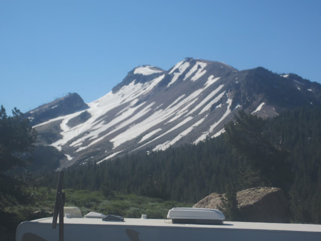 |
| Mammoth Mountain summit in the middle, you can just see the gondola structures going up |
 |
| Another record this time the highest we have ever been. |
We loved our quick look so much we found a camp in the
nearby forest and stayed 3 days, 1 day longer than expected due to a case of
Gout invading my right big toe, which grew overnight to mammoth proportions.
Luckily we brought the remedial treatment and had a night off the grog.
 |
| Jen sizing up her snowballs |
 |
| Rather than take the gondola down I tried my hand at cross country skiing in my Aussie snow gear |
It’s so amazing that 1 day we were in the lowest place both
of us have ever been on the planet and the next day we are in the highest place
we have ever been. A difference of 11,337 feet elevation, surprising we didn’t
suffer altitude sickness. Maybe all the ups and downs acclimatised us. Maybe
that’s what brought on my gout?? Who knows!!
 |
| Horseshoe Lake one of the highest of the Mammoth Lakes |
 |
| Part of Horseshoe Lake has been affected by CO2 gas coming to the surface after some seismic activity in recent years resulting in many trees dying |
 |
| Crystal Crag as seen across George Lake |
 |
| One of the beautiful Mammoth Lakes |
 |
| A waterfall carrying water from one lake to another below |
 |
| The Minaret Peaks another mountain range behind Mammoth Mountain but still within the Sierra Navada |
See Yawl!!!
Beers and Cheers from the top of USA, getting high on snowball cocktails
J&J


No comments:
Post a Comment