At precisely 3:10 we crossed the
Arizona border into Yuma just ahead of the train, waved to Russell and went
straight to the laundrette for the first of our fortnightly chores. Sound
boring, well no, it’s where we get to meet the local folk, all kinds of locals!!!
In the U.S. these facilities are very much in demand, well decked out with
machines of all sizes and some even have café’s attached.
 |
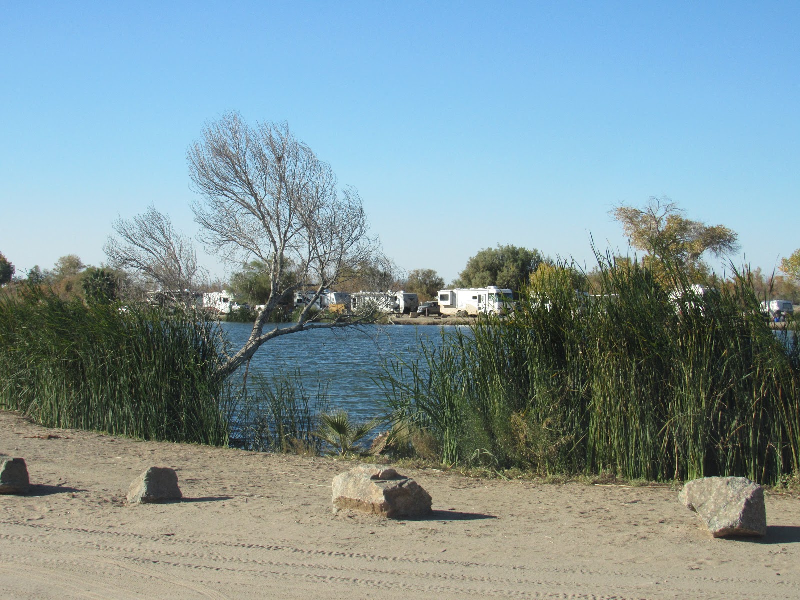
| The not so mighty Colorado River at Yuma, it no longer flows into the Gulf of California as it's contents are siphoned off by all the states it traverses and the last trickle by Mexico |
 |
| One of the many canals draining water from the Colorado |
In addition to washing we had to
dump the holding tanks and fill the water tank, a task that requires much
planning as preferably we have to find a location that can cater to both needs
not just one or the other. We found one on our Sanidump App 12 miles out of
town so we headed out only to find a queue lined up which we were happy to
join. Just before our turn the guy in front of us decided he needed to get
closer to the water hose and in doing so caught the pipe on his rear bumper and
then right in front of my eyes he went forward ripping it out of the ground and
broke the pipe sending a stream of water into the air. We’re in the desert
where water is precious and he came up and said “oh well at least you can still
dump” and I said “what under an umbrella do you happen to have one because I don’t”.
 |
| Our camp outside Yuma |
Anyway we took off before anyone
could blame us or claim we were an accessory to the fact and headed back into
town to try our luck again and maybe god forbid have to pay. We did strike it
lucky at another location having to leave my driver’s licence as security for a
key to unlock both tap and dump lid.
 |
| Masses of vegetable crops growing in the desert thanks to the Colorado River |
In addition to all this we still
had to gas up, fill the propane tank, buy more beer and get some fruit and
veges, lucky our next camp was close by. The camp was about 10 miles out of
town along East 7 ½ Street, only in the states would there be a ½ street and
yes it was between East 7 and East 8, obviously we know this because we drove
straight passed it didn’t we!! It was a dirt track and barely a street at all
so we guessed it made some sort of sense.
 |
| The desert back roads are a pleasure to drive on and thankfully don't attract too many trucks |
The next day we continued on from
Yuma heading north deeper into the Sonoran Desert which covers 260,000 km2 the whole of
southern Arizona and northern Mexico east of the Colorado River and west of the Continental Divide. The temperature is nice in winter 5 – 25 Celsius and
blistering in summer getting above 60 Celsius, hence us being here now!! It’s
our intent to zigzag our way east through this desert region to see how it
varies from north to south and west to east while trying to keep warm in the process.
 |
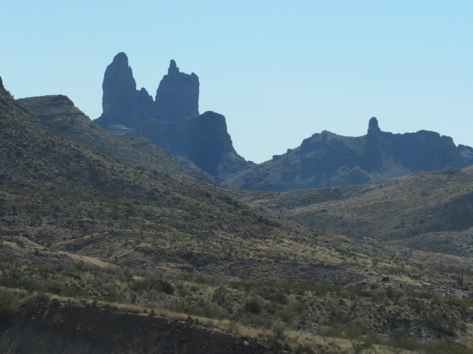
| The Dome Mountains one of many ranges that rise our of the desert |
 |
| Another of the uniquely carved desert mountains |
In the first section west of
Phoenix we found some very peaceful BLM camps with fantastic views of the
weathered mountains which sprung up everywhere around us. The vegetation is
spectacular in this sparse area and uniquely beautiful with not only cacti but
bushy trees which have adapted to these harsh conditions. The Sonoran Desert
averages only 8 inches of rain per year, winter rain is light and soaking while
summer rain comes in violent storms causing flash flooding and much erosion.
 |
| The Saguaro (pronounced sa-WAH-row) Cactus an icon of the Sonoran Desert. They grow for 150 to 200 years taking as long as 60 years before the first arm shoots out |
 |
| All the Saguaro are different with individual shapes and remind us of alien sentinels standing guard over the desert |
 |
| A baby saguaro, every summer when mature they have red berries on top which the local Indians very carefully collect and make Saguaro Jam |
The animals in the desert are
separated into 2 groups, daylight dwellers which are primarily birds and
insects with the other night time dwellers which are mammals and reptiles, the
food surprisingly very plentiful and water mainly derived from within the food
they consume. Many of the smaller mammals live in burrows underground to avoid
the predators and the heat of summer.
 |
| Very much a day dweller this Golden Eagle is on constant watch for any critter not paying attention |
 |
| The infamous Road Runner, photographed here in very slow motion, they do literally race across the road in a blur |
 |
| A very pretty Pyrrhuloxia is very careful not to land on a spike |
It was a very pleasant Xmas
relaxing in the desert recovering from a bout of gout which had reoccurred
after our trip to Mexico. We headed for Phoenix to Cruise America where we
purchased the motorhome. Since we were passing we thought we may as well pick
up our replacement rear bumper which was damaged in the rear - ender we
suffered at Fresno in 2016. In addition we got a couple of new shower tap knobs
as one had previously broken and a replacement window catch which was damaged
during last year’s bumpy trip to Alaska. The items were purchased at cost
courtesy of Cruise America but still attracted the local taxes of nearly 8% a
bargain compared to the retailers and their XXX% mark-ups pre-tax.
 |
| The coyote like our dingo is very cunning and needs to be watched carefully, they also hunt in packs. We hear these guys howling most nights we camp in the desert. |
Phoenix is the cheapest place we
have found so far to buy booze, 30 carton of full strength Coors beer is US$17
and a 1.75 litre bottle of quality rum is US$18, admittedly not cheap, cheap
like the Philippines but the best in USA and Canada, even Mexico can’t match
these prices. We now have enough beer and rum to last the whole trip and enough
for our duty free return to OZ. It’s also the cheapest gas we have found @ US$2
per gallon about A$0.65 per litre, shame we can’t buy a whole trips worth in
one go.
 |
| Generally a night dweller the Gila (pronounced Hee-lah) Monster a major member of the desert clan |
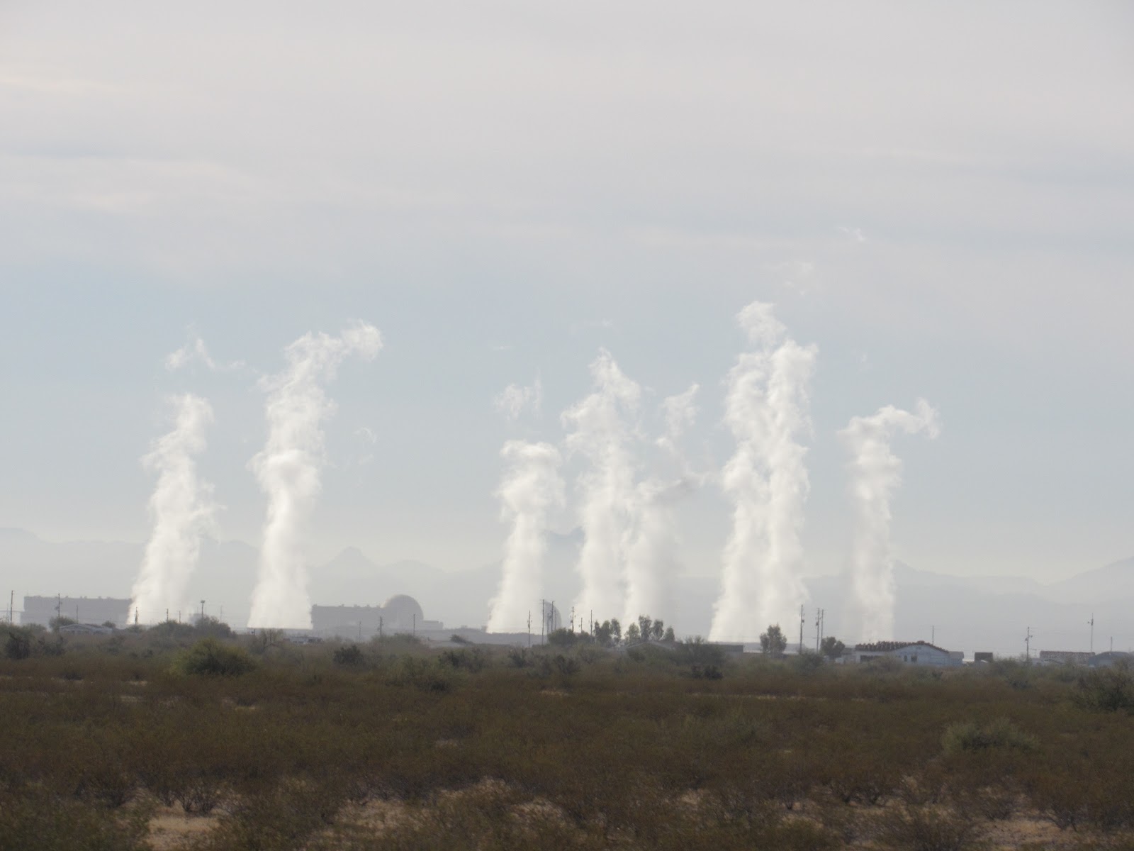
With all the tasks completed in
the big smoke (literally as Arizona is backward compared to most other states
with the bulk of their power derived from dinosaur non-renewable technology
polluting the area with masses of smog). We departed Phoenix and 2 hours later
found a camp in the dark just on the outskirts at a small town called Buckeye.
 |
| We left Phoenix with stinging eyes due to the persistent smog that hangs in the basin. |
Despite the roads around Phoenix
being monstrously wide up to 6 lanes each way the traffic was very congested
and a nightmare to travel on, as vehicles and trucks if not hurtling along at
70 mph were pushing and shoving their way in front. Over here they don’t
believe in 1 car distance for every 10mph they tailgate at 90mph even if the posted
limit is 75mph which is very fast anyway. You have to watch every direction
virtually at the same time. We hate and try to avoid the cities and interstate
highways for this very reason. On these roads sometimes you have to cross 5
lanes to make a turn so the planning needs to start a long way before. Despite
the deathly speeds they all travel we must admit the yanks certainly know how
to build highways to move the masses.
 |
| You need eyes in the front, back and both sides of your head to drive the highways here |
It was good to be back in the
wide open desert headed south again, this time to the Organ Pipe Cactus
National Monument, its located just north of the Mexican Border and pretty much
dead centre of the Sonoran Desert. The park is host to masses of cacti from the
very small to the enormous Saguaro and of course the Organ Pipe variety which
are only found here within the USA, mostly located in Mexico below the frost line.
 |
| The Organ Pipe Cactus are more common in Mexico and only survive in the NP where it can avoid sub zero temperatures |
 |
| A Cholla (pronounced CHOY-yoh) Cactus one of very few still with its yellow seed pods |
 |
| The Prickly Pear Cactus in its native environment is not a pest and plays a very important part in the Sonoran Desert's ecosystem |
 |
| A birds nest cactus making the most of its neighbours kindness |
We drove the 21 mile one way loop
road despite officially being too big (long and wide) at a maximum speed of 10
mph, which was a far cry from the previous couple of days. The dirt road was badly
corrugated and rutted for the entire length but the scenery was fantastic as we
climbed up and around the desert mountains.
 |
| Almost a mirror image these 2 saguaro have many arms |
About half way around we went for
a short 2 mile hike which turned into a 4 mile mountain climb as we confused
the trail entry sign for indicating a looping trail which did in fact not loop
at all but went straight up and up. We were informed half way up by a pair of
jovial returning climbers that we were numbers 11 and 12 for the day, we were
only half way and luckily we had worn boots and taken water. It was very
strenuous and we were more than relieved when we returned to Arvee. Certainly
more relieved than the pair that passed us on our return asking if we had seen
a cell phone. OH BUGGER!!!
 |
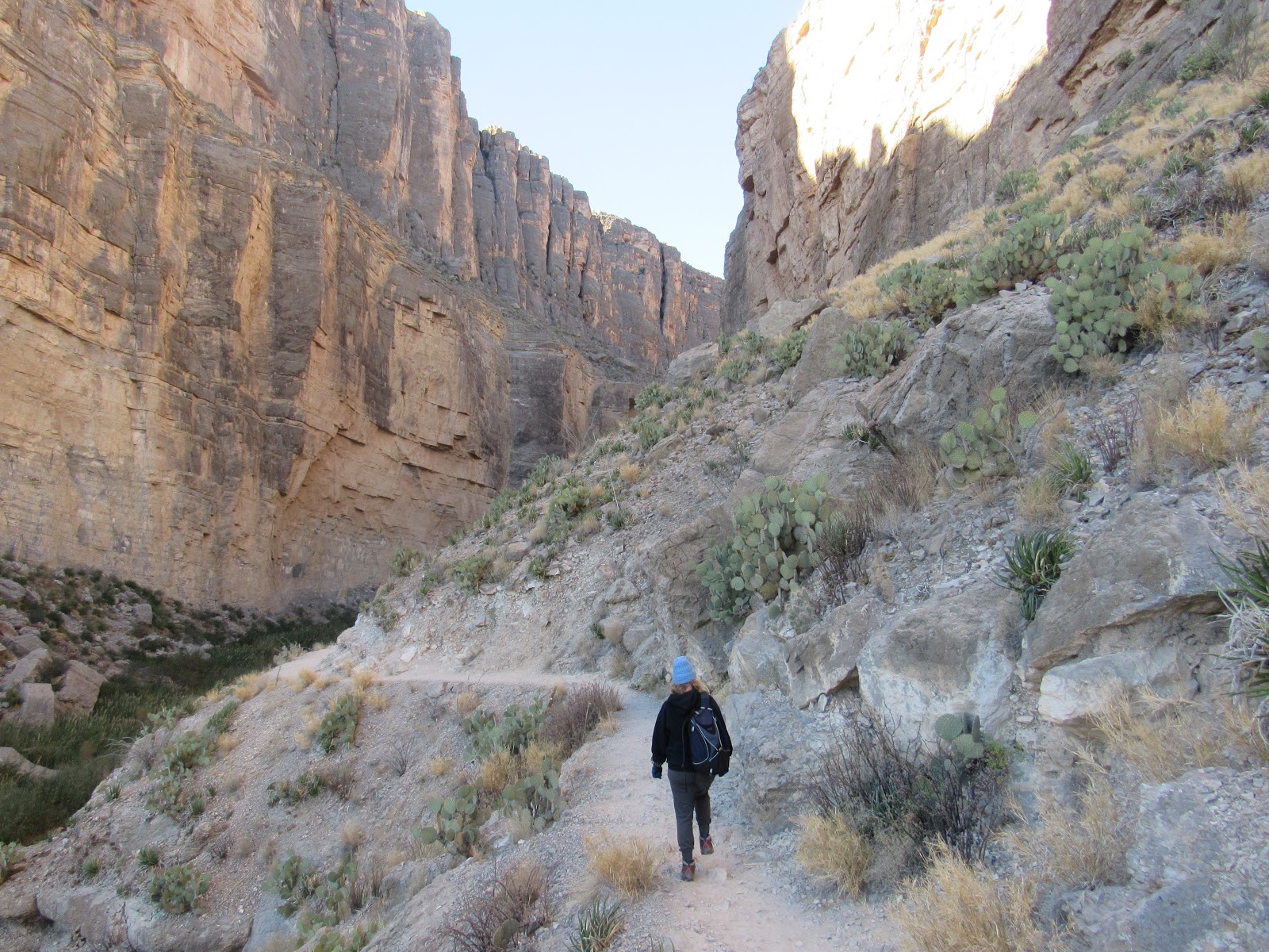
| The double arch above Arch Canyon Trail |
 |
| The view from the top of Arch Canyon looking south to Mexico and over the Organ Pipe Cactus NP |
Many of the desert plants live a
symbiotic life with other plants and also animals to ensure continuation of
their own species even if it means destruction of its host when the appropriate
time comes. The adaptive abilities of these plants and animals is amazing and a
part of this is the local indigenous people Tohono O’odham Indians who live in
a reservation adjacent to the NP. They have survived the harsh desert
conditions for eons living comfortably from what they sourced here.
 |
| A mature Saguaro cactus still living with its host green stemmed Palo Verde (pronounced PA-loh-VAIR-deh) |
 |
| Indian wall mural in Ajo (pronounced AH-hoe) depicts a much more serene existence |
New Year’s Eve was spent trying
to sleep in what seemed to us a war zone at Tucson City. Private fireworks,
mainly bungers were going off all night along with constant gunfire as the “cowboys”
celebrated. The idea of the city providing a communal fireworks display would be abhorrent
to the wealthy town folk here ensuring none of their taxes were used to
entertain the poor or less fortunate, unlike in OZ they don’t count over here. This
behaviour is pretty standard across the USA where public money is directed in
appropriate amounts back to those from where it was derived. It’s very much a
pay as you go society a system that thrives and grows on greed. Communal spending of public money is virtually outlawed. Obamacare the
U.S. version of our Medicare is a classic example!!
 |
| This Indian wall mural depicts a landscape long gone but not forgotten |
Heading southeast from Tucson we
left the lower desert and went back in time as we came face to face with the
wild west. Back in the 1800’s people
swarmed across the Mississippi River in search of their very own fortune
believed to be locked up inside the hills of the west country. Gold fever hit and
along with gold every other precious metal that could be found was extracted as
quickly as possible so no one else could get it. Along with this came wild
living where life was worth less than the cost of a whisky.
 |
| This bloke was only worth a beer |
 |
| Lavender Pit lies within meters of the township of Bisbee and is an example of environmental vandalism remaining 30 years after it last operated as a very profitable copper mine |
A prospector
left Tucson in search of his fortune and was told he would find nothing but his
own tombstone. He did in fact find massive silver ore deposits and named the place Tombstone
after the sanctimonious torment he received. The town quickly became the epitome
of the wild west as we have all seen in movies with The Earp Brothers and Doc
Holliday cleaning up the town by killing as many people as they could. Only here
in the good old USA would they glorify a gunfight where people untried by a
court are killed as a matter of convenience. The “Shoot Out at the OK Corral”
was one such event and for 363 days a year is re-enacted 3 times a day for the meagre
price of US$10 per person.
 |
| The 3 Earp brothers in black from left Virgil, Morgan and Wyatt with Doc Holliday making their way down to the OK Corral for what turned out to be a very famous gun fight |
 |
| The famous Chiricahua Apache Indian Geronimo had a very tough life with his 1,000 strong tribe constantly being attacked by both the U.S. and Mexican Armies, but he, his son Chappo and his tribal chief Cochise were defiant to the end |
Tombstone is a quaint trip in
history but if you look closely today, society is still driven by greed, cowboys still have horse
power under their arse and police kill who they chose, so nothing much
has changed really!!!
 |
| I think the author here sums it up, shame our politicians don't have the same wisdom |
Beers and Cheers with a Coors stubby at the Doc Holliday Saloon in Tombstone, Arizona
J&J